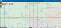
I noticed today that there are areas in which the FAA Facility Grid indicates a LAANC altitude, but are not available to be authorized for LAANC. For instance, Fairbanks, AK has several areas in which the FAA Facility Grid indicates an altitude (200 feet in the attached photo, for instance) but the grid is still highlighted in red. This red indicates that the area is not able to be approved via LAANC. (If you dig into the ESRI metadata for the grid, the red shading is because the grid has a "LAANC Readiness Status" for at least one of its airport areas of "0".)
In the attached example, the grid areas are in Class D, but are not part of a Prohibited Area, National Security UAS Flight Restricted area, or any other obvious thing that make it unique from the other LAANC-approved grid squares in the vicinity.
Does anyone have any guesses on why these grid squares would have a LAANC altitude assigned, but are simultaneously tagged as not being available for LAANC approval?