

So I did my first test with my M30T using MME and the overall results were good from far away but zoomed in, the edges of roofs or really any contrasting edge were pixelated and missing sections as well as a few swirly trees. I have a mission at the end of the month for a corn maze but it's not the typical mapping mission where the client wants all the metadata results or incredibly sharp detail of each corn stalk. All they want is a nice aerial image of the maze.
Last year I was hired to provide them an aerial photo of the maze for the farm's social media and for the client as it was their design. The field is 1362ft long and 200ft wide so at 400ft altitude, my Air 2 obviously couldn't get the maze in one shot. Even if I wanted to break the the ceiling and get up high enough with my Air 2, the property is barley (and I mean barely) outside the perimeter of Class C airspace and about 1/2 mile east of the flight path so that wasn't happening. At the time, I didn't know about mapping missions so I took a series of photos that I stitched together in Photoshop and it was a nightmare for a few reasons. So my idea this year was to fly a mapping mission over the maze and let a company like MME do the stitching.
So the test in my neighborhood was 65 images over a 3.80 acre area at 150ft AGL with an 80% overlap (see breakdown below). If it matters, I was running with RTK using PointOneNavigation but it was only to make the drone more accurate in its flight and not for any measurement.

When I inquired about the jaggies on the roofs, Zane over at MME replied with the following:
Greg,
Try to correlate the areas that didn't turn out well to the same spot in the Overlap Report at the bottom. For something to turn out well you really need to have 16+ views at it. If not more. This is why we recommend using 80% overlap. There is some filtering on the model that goes on and vertical features are always going to be slightly affected. It doesn't really have much to do with the speed the images were taken at as long as there isn't streaking in the source images.
Thanks,
Zane
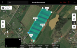
Here is the overlap report he mentioned from my mission and here is a explanation from their site on how the report works:

Here is the RGB render from the mission (Google Drive)
To me, the houses in the center of the image are in the blue area of the overlap report so I guess I'm not understanding why I got those results. The explanation page above states "9 or more views (blues) is required to have the detail necessary to reconstruct complex objects like buildings, trees or other vegetation." and that area in my report is in the 14+ range. Again, this is for a corn maze and probably won't have these issues but I'd like know what I can adjust on my side before the mission at the end of the month. I am headed out to the maze this weekend to show them aerials of a particular section they had issues with last season and will also be doing a mapping test run just to run though the process and make sure the results are good enough. If there's something I should adjust like lowering the altitude to increase the picture count or maybe increase the overlap to 90% or something, let me know. Zane did say speed or lack of mechanical shutter wouldn't have mattered in this case.
Unfortunately I can't post this weekend's results as the farm and the client don't want anything released on the internet until a week before the opening.
Last year I was hired to provide them an aerial photo of the maze for the farm's social media and for the client as it was their design. The field is 1362ft long and 200ft wide so at 400ft altitude, my Air 2 obviously couldn't get the maze in one shot. Even if I wanted to break the the ceiling and get up high enough with my Air 2, the property is barley (and I mean barely) outside the perimeter of Class C airspace and about 1/2 mile east of the flight path so that wasn't happening. At the time, I didn't know about mapping missions so I took a series of photos that I stitched together in Photoshop and it was a nightmare for a few reasons. So my idea this year was to fly a mapping mission over the maze and let a company like MME do the stitching.
So the test in my neighborhood was 65 images over a 3.80 acre area at 150ft AGL with an 80% overlap (see breakdown below). If it matters, I was running with RTK using PointOneNavigation but it was only to make the drone more accurate in its flight and not for any measurement.
When I inquired about the jaggies on the roofs, Zane over at MME replied with the following:
Greg,
Try to correlate the areas that didn't turn out well to the same spot in the Overlap Report at the bottom. For something to turn out well you really need to have 16+ views at it. If not more. This is why we recommend using 80% overlap. There is some filtering on the model that goes on and vertical features are always going to be slightly affected. It doesn't really have much to do with the speed the images were taken at as long as there isn't streaking in the source images.
Thanks,
Zane
Here is the overlap report he mentioned from my mission and here is a explanation from their site on how the report works:
Here is the RGB render from the mission (Google Drive)
To me, the houses in the center of the image are in the blue area of the overlap report so I guess I'm not understanding why I got those results. The explanation page above states "9 or more views (blues) is required to have the detail necessary to reconstruct complex objects like buildings, trees or other vegetation." and that area in my report is in the 14+ range. Again, this is for a corn maze and probably won't have these issues but I'd like know what I can adjust on my side before the mission at the end of the month. I am headed out to the maze this weekend to show them aerials of a particular section they had issues with last season and will also be doing a mapping test run just to run though the process and make sure the results are good enough. If there's something I should adjust like lowering the altitude to increase the picture count or maybe increase the overlap to 90% or something, let me know. Zane did say speed or lack of mechanical shutter wouldn't have mattered in this case.
Unfortunately I can't post this weekend's results as the farm and the client don't want anything released on the internet until a week before the opening.
Last edited:


")


