

You are using an out of date browser. It may not display this or other websites correctly.
You should upgrade or use an alternative browser.
You should upgrade or use an alternative browser.
Using my City wide authorinzation
- Thread starter Recoveryone
- Start date


Phaedrus
Well-Known Member
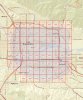
Is that the old Norton AFB (San Bernardino International) in the background?
Hawaii Drone Imaging
Well-Known Member
Yes it is @Phaedrus. I live 15 minutes from there. I used to work at those dome hangars in the back behind the tower. The center square one used to be the sheriff department, but they relocated. UPS is leasing it now and uses it for overflow shipments. Most of the airplanes there are out of service and were purchased by my old employer to dismantle them and refurb the parts to sell again, ie engines, flaps, landing gear, avionics etc etc. Some of the planes are owned by airlines and are being "stored" because they are not in use at the moment. The forestry service is there also and has a ramp for the fire birds. They actually built an "International Terminal" that a couple of airlines from Mexico use for flights. I don't miss it...HOT as H3ll in the summer on the flight line and freezing cold in the winter mornings..lol
Nice shots @Recoveryone. Lots of new warehouse action going on in that area. I think Amazon is leasing up a bunch of em eh?
Nice shots @Recoveryone. Lots of new warehouse action going on in that area. I think Amazon is leasing up a bunch of em eh?
Last edited:
Nice shots @Recoveryone. Lots of new warehouse action going on in that area. I think Amazon is leasing up a bunch of em eh?
The site that I am inspecting will be a new Amazon ramp facility, just like UPS & Fedex has on the old base. Hillwood (Ross Perot family), is the main developer of most of the warehouses in the area, you can identify them by the stars on the building.
The site that I am inspecting will be a new Amazon ramp facility, just like UPS & Fedex has on the old base. Hillwood (Ross Perot family), is the main developer of most of the warehouses in the area, you can identify them by the stars on the building.
skiptv
Well-Known Member
- Joined
- Apr 14, 2018
- Messages
- 150
- Reaction score
- 94
- Location
- Hollywood California
- Website
- www.hollywood-drones.net
So you are saying you got a part 107 Waiver to fly there. (the entire city) ? I also know the area very well as I am doing promotional videos for serval warehouse properties in the area, there is no LAANC and I had to get a 107 Waiver, and it certainly was not city wide, it was based on individual Locations. I know the area over the warehouse on Waterman Ave. Pictured is '0' airspace in addition to the pad right next to the airport. I'd love to know how to get a 'city wide 107 authorization
Hawaii Drone Imaging
Well-Known Member
@skiptv - I have a "Wide Area" authorization for SBD, Class D. I'm only required to call SBD NFCT 15 minutes prior to flight and again when I complete my flights. I still have to check for TFRs or Prohibited Airspace warnings. I have to also check FAA UAS Data Delivery Service and follow allowable altitude limits for the area. If I need to use any of the "0" altitude areas, I can ask for permission when I call the tower to notify them of my flight and they can approve me for that space for the time needed. My authorization was issued in 1 year increment. I am due for renewal September 2020. Maybe that's what @Recoveryone is speaking of when saying "city wide".
Attachments
Last edited:
skiptv
Well-Known Member
- Joined
- Apr 14, 2018
- Messages
- 150
- Reaction score
- 94
- Location
- Hollywood California
- Website
- www.hollywood-drones.net
@skiptv - I have a "Wide Area" authorization for SBD, Class D. I'm only required to call SBD NFCT 15 minutes prior to flight and again when I complete my flights. I still have to check for TFRs or Prohibited Airspace warnings. I have to also check FAA UAS Data Delivery Service and follow allowable airspace limits for the area. If I need to use and of the "0" altitude areas, I can ask for permission when I call the tower to notify them of my flight and they can approve me for that space for the time needed. My authorization was issued in 1 year increment. I am due for renewal September 2020. Maybe that's what @Recoveryone is speaking of when saying "city wide".
Thanks so much for the information, makes sense now, yes I didn't understand the 'city wide' thing. Your information and description was perfect, thanks I just learned a 'new thing'.
Stay Safe and Have a great day.
I work for the city, but my COA is for meSo you are saying you got a part 107 Waiver to fly there. (the entire city) ? I also know the area very well as I am doing promotional videos for serval warehouse properties in the area, there is no LAANC and I had to get a 107 Waiver, and it certainly was not city wide, it was based on individual Locations. I know the area over the warehouse on Waterman Ave. Pictured is '0' airspace in addition to the pad right next to the airport. I'd love to know how to get a 'city wide 107 authorization
AUTHORIZEDOperations under this certificate of authorization (COA) are limited to the maximum altitude listed below. This altitude is an absolute value and it shall not be added to the height of any structures. Class of Airspace: At or Below: Altitudes in accordance with published Unmanned Aircraft System (UAS) Facility Map (UASFM).Under the Jurisdiction of: San Bernardino Non-Federal Contract Tower (NFCT)Airport Identifier: San Bernardino International Airport/ KSBD
are you doing work for Mille Severson
Last edited:
skiptv
Well-Known Member
- Joined
- Apr 14, 2018
- Messages
- 150
- Reaction score
- 94
- Location
- Hollywood California
- Website
- www.hollywood-drones.net
I work for the city, but my COA is for me
AUTHORIZEDOperations under this certificate of authorization (COA) are limited to the maximum altitude listed below. This altitude is an absolute value and it shall not be added to the height of any structures. Class of Airspace: At or Below: Altitudes in accordance with published Unmanned Aircraft System (UAS) Facility Map (UASFM).Under the Jurisdiction of: San Bernardino Non-Federal Contract Tower (NFCT)Airport Identifier: San Bernardino International Airport/ KSBD
are you doing work for Mille Severson
Thanks for the info, I know how to get the 107s But I had to get them for each separate property location, I did not know I could get a 'blanket coverage". Yes I have a contract with them and I have been filming their projects across the state for the last 4 years.
Mavic Mac
Well-Known Member
- Joined
- Oct 2, 2019
- Messages
- 296
- Reaction score
- 170
@skiptvThanks for the info, I know how to get the 107s But I had to get them for each separate property location, I did not know I could get a 'blanket coverage". Yes I have a contract with them and I have been filming their projects across the state for the last 4 years.
I had applied for my first flight authorization for a limited area in controlled airspace. I was much surprised when I received a call the following day from the FAA. The lady asked if I this was my first request. She then asked if I know or was aware of wide area authorization. I told her I was not. She explained that she was giving my authorization for the entire controlled air space, not just the limited area I requested. She also extended the time period for my authorization by a few months.
Phaedrus
Well-Known Member
I work for the city, but my COA is for me
AUTHORIZEDOperations under this certificate of authorization (COA) are limited to the maximum altitude listed below. This altitude is an absolute value and it shall not be added to the height of any structures. Class of Airspace: At or Below: Altitudes in accordance with published Unmanned Aircraft System (UAS) Facility Map (UASFM).Under the Jurisdiction of: San Bernardino Non-Federal Contract Tower (NFCT)Airport Identifier: San Bernardino International Airport/ KSBD
are you doing work for Mille Severson
So if you are required to be at or below the UASFM map altitudes how are you handling getting cleared to exceed those? Do you do that during the required call to the tower in your COA? It looks like most of the images you posted are in the zero grid zones.
Yes, calls are made with contractor, Airport operations and TowerSo if you are required to be at or below the UASFM map altitudes how are you handling getting cleared to exceed those? Do you do that during the required call to the tower in your COA? It looks like most of the images you posted are in the zero grid zones.
Also
SCHEDULE OF FLIGHT OPERATIONS:
a. This COA and the Special Provisions shall be in effect between civil sunrise and civil sunset local time.
b. This COA does not relieve the remote pilots from the responsibility to check the airspace they are operating in and comply with all restrictions that may be present in accordance with, see 14 CFR 107.45 and 107.49 (a)(2), such as restricted and Prohibited Airspace, Temporary Flight Restrictions, etc.
c. The facility may disapprove, terminate, restrict, or delay UAS flight operations covered by this COA at any time.
d. The operator is responsible for reviewing the current UASFM prior to each flight, noting any changes to the area of operations (i.e., altitude changes, airspace modifications, temporary flight restrictions, etc.). Open the UASFM website at FAA UAS Data Delivery Service, scroll down and open the “Visualize It” section. If you need to operate at an altitude that is above the published UASFM, you must apply for a new COA requesting that location and altitude.
3. EMERGENCY/CONTINGENCY PROCEDURES - Lost Link/Lost Communications Procedures:
a. If the UAS loses communications or loses its Global Positioning System signal, the Unmanned Aircraft must return to a pre-determined location within the operating area and land.
b. The Pilot in Command must abort the flight in the event of unpredicted obstacles or emergencies.
When I appiled I asked for max altitude 400'
Last edited:
william strong
Member
- Joined
- Nov 25, 2019
- Messages
- 7
- Reaction score
- 3
- Age
- 71
I applied for and got a two-year blanket coverage in the Vegas area- Airspace Authorization: Blanket Coverage of Henderson, NV Executive Airport Class D Airspace.
I tried to get the same coverage in the Las Vegas Class B airspace and was denied.
I tried to get the same coverage in the Las Vegas Class B airspace and was denied.
Phaedrus
Well-Known Member
I fly in KLAX airspace fairly often. LANNC at or below grid altitude is instant, but exceeding grid (up to 400 feet) has never taken more than a few hours to get. I've flown a bunch in Zero Grids.
william strong
Member
- Joined
- Nov 25, 2019
- Messages
- 7
- Reaction score
- 3
- Age
- 71
So what is your process for getting cleared in Zero grid areas?I fly in KLAX airspace fairly often. LANNC at or below grid altitude is instant, but exceeding grid (up to 400 feet) has never taken more than a few hours to get. I've flown a bunch in Zero Grids.
Phaedrus
Well-Known Member
So what is your process for getting cleared in Zero grid areas?
I use Airmap or Kittyhawk to do LAANC and request higher altitude, but still below 400 feet. Always worked in the places I needed. Takes +/- 8 hrs to get authorization.


New Posts
-

-
 Sharing My Music and Sound Effects - Over 2000 Tracks
- Latest: Eric Matyas
-

-

-