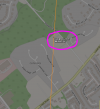
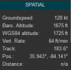
So this Life-star helicopter flew right over my neighborhood this evening and I swear he was near 400 AGL max. I wasn't flying but I would have shipped my pants (Kmart commercial reference) if I was. I'm sure he has ADS-B but I just made a post this weekend about not getting ADS-B warnings on my radio form a Cessna flying over but at a much higher altitude. Anyway, I played back the Life-star flight and it says he was at 1650 calibrated altitude right over my house. Figuring that's MSL, I deducted 900ft from my home's MSL and got 750ft. Ain't no way he was 750ft AGL. Is my math wrong or am I leaving out some adjustment the pilot sets for barometric pressure?
Google says "Calibrated altitude is corrected for nonstandard atmospheric conditions. It is the actual height above mean sea level, as if measured with a tape measure. Elevations of airports, mountaintops, towers and other obstructions are given in true altitude".
I know sometimes looks can be deceiving when looking at objects in the distance or in this case in the air but I'm telling you, I'm pretty sure I know the difference between 400ish feet and 750ft. Just ranting. No point to this post.