Latest activity
-
Aairdonkey replied to the thread Auto takeoff and Landing icons not showing up on my fly screen..I posted this on the phantom site as well... My current experiences and research are telling me that the auto-takeoff and landing icons do not appear on the GS RTK app screen. I know the RTH icon WAS there when I first turned on the unit. I...
-
 adm_geomatics replied to the thread Solar installation surveys - software recommendations.DroneDeploy is free for flight so I'm assuming you're talking about processing?
 -
adm_geomatics replied to the thread Looking for a high nit phone or tablet, any suggestions? good battery life as well?.It’s funny this just popped up because I bought one of these about a week ago and it is an amazing device. $160 on Amazon. Yeah, I know, right?! https://a.co/d/j1axBKL
-
 Eric Matyas replied to the thread Sharing My Music and Sound Effects - Over 2000 Tracks.Greetings Fellow Creatives, I have some cool new music tracks to share with the community. 100% free to use with attribution, like my thousands of other tracks. They are: On my Dark/Ominous 2 page: "BUMP IN THE NIGHT" (LoFi) "STRANGER NIGHTS"...
 -
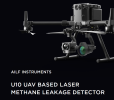
 syazoo replied to the thread Zenmuse Ailf U10 LASERMETHANE LEAKAGE DETECTOR.BTW, Located in Regina, Saskatchewan Canada. We can work out shipping/delivery easily. I do not mind travelling.
 -
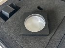
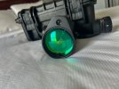
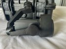
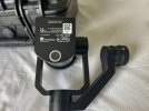
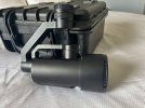
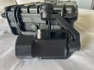
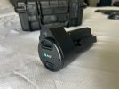
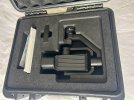
Price is $55,000 USD Manufactured Sept, 2022. In Service May, 2023. Total use ~ 5 hours. I am selling our training unit Zenmuse Ailf U10 LASER METHANE LEAKAGE DETECTOR. I highly doubt this camera has more than 5 hours use. It can be used on...
-
-
SStedmanWheless replied to the thread Like New Matrice 300 RTK.I do still have it. I was hoping to get $7,000 + shipping/insurance out of it. What do you think about that?
-
syazoo replied to the thread Like New Matrice 300 RTK.If you still have it, do you have a price in mind?
-
 What a great idea to have a forum for commercial pilots! This is really needed and can't wait to dive into, thank you!
 -
adm_geomatics replied to the thread Hello.Welcome from Texas @Catastrophe !
-
CWhat a great idea to have a forum for commercial pilots! This is really needed and can't wait to dive into, thank you!
-
JHey, thanks for the information! As I mentioned, I am studying about GIS at school, which uses ESRI’s ArcGIS that can do mapping and NDVI image processing with it. It’s a very pricey program, but we get it with a student license. I like that...
-
Aairdonkey posted the thread Auto takeoff and Landing icons not showing up on my fly screen. in General Discussions.I'm new, so don't give me the benefit of the doubt that I know what I'm doing and have already checked the basics! But I know enough to know that on my fly screen (on my Phantom 4 RTK) I should see an auto-takeoff and auto-landing icons. I see...
-
-
Aairdonkey posted the thread Hello all. Newbie X2: Surveyor to be and Just getting into Drones. in Introductions....Specifically Phantom4 RTK. Glad to be here. And of course, I already have questions, which I posted to the General Discussion... Cheers!
-
 AMann replied to the thread Professional Land Surveyor in Los Angeles, California.Hi Tony, good job on the 107! I bet it wasn’t anything like what you accomplished with getting your surveyors license though, I looked into what those would take once and realized that it would be a lot of work and time, so congratulations on...
 -
AMann replied to the thread Weed mapping for spot spraying.Hey, thanks for the information! As I mentioned, I am studying about GIS at school, which uses ESRI’s ArcGIS that can do mapping and NDVI image processing with it. It’s a very pricey program, but we get it with a student license. I like that...
-
Jjaja6009 replied to the thread Weed mapping for spot spraying.Right now on the Mavic sister site, there is a Mavic 3 M for sale at a good price. The forum member has a decent history so it seems legit.
-
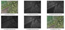
To collect images, it is similar to mapping with RGB. You just need an app to plan your grid missions. Pilot 2 works as well as Pix4d Capture Pro and probably some others. The images saved are RGB, Green, Near Infrared, Red, Red Edge and are not...
-
Jjaja6009 replied to the thread Weed mapping for spot spraying.To collect images, it is similar to mapping with RGB. You just need an app to plan your grid missions. Pilot 2 works as well as Pix4d Capture Pro and probably some others. The images saved are RGB, Green, Near Infrared, Red, Red Edge and are not...
-
-
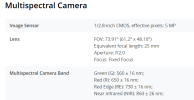
JI’m interested in this as well, particularly in multispectral vegetation surveys. Currently using a Mavic 2 Pro that was modified to do multispectral photography, but am interested in the Mavic 3 Multispectral RTK model. Does anyone here use...
-
AMann replied to the thread Weed mapping for spot spraying.I’m interested in this as well, particularly in multispectral vegetation surveys. Currently using a Mavic 2 Pro that was modified to do multispectral photography, but am interested in the Mavic 3 Multispectral RTK model. Does anyone here use...
-
FFalcon200 reacted to Eric Matyas's post in the thread Sharing My Music and Sound Effects - Over 2000 Tracks with
 Like.
Hi Everyone, I've created and uploaded some brand new music tracks to share with the community: "PIXEL BALLOONS" "PIXEL BALLOONS_v1" "PIXEL BALLOONS_v2" You'll find them here: Puzzle Music 8 | Soundimage.org As always, they're 100% free to...
Like.
Hi Everyone, I've created and uploaded some brand new music tracks to share with the community: "PIXEL BALLOONS" "PIXEL BALLOONS_v1" "PIXEL BALLOONS_v2" You'll find them here: Puzzle Music 8 | Soundimage.org As always, they're 100% free to... -
FFalcon200 reacted to Eric Matyas's post in the thread Sharing My Music and Sound Effects - Over 2000 Tracks with Like.
Another super-busy week, but I did manage to create a new free music track (with variations) for the community: "ARCADE SPACE QUEST " Sci-Fi 14 | Soundimage.org This track has 5 additional variations which might be useful for various levels...
-
 Dave Pitman replied to the thread Professional Land Surveyor in Los Angeles, California.Hello Tony. Congrats on the 107! You are correct, of course, that drones are a tremendously powerful tool to add to your kit. Good Luck!