Latest activity
-
DDeep South Drones replied to the thread Habitat Analysis with an IR modified Mavic Pro 2.Interesting exercise but why not just use a Mavic 3M since it is already set up to do a much more accurate and faster job of accomplishing the same goal?
-
 AMann replied to the thread I am looking for the flight control system for a manned aircraft..Ardupilot is open source and there are a lot of commercially available flight controllers that are compatible with it. Hope you have a recovery chute on the thing- fly safe!
 -
JJason Chen posted the thread I am looking for the flight control system for a manned aircraft. in General Discussions.I'm looking for a flight controller for my 150kg multi-rotor aircraft. Could you share which flight control system you use? Thanks.
-
WWing reacted to Dave Coon's post in the thread Selling: DJI Mavic 3 Enterprise Kit w/ RTK Module, RC Pro, and 4 Batteries with
 Like.
Probably gone, but I'll ask any way. Is this still for sale and what are you asking?
Like.
Probably gone, but I'll ask any way. Is this still for sale and what are you asking? -
DDave Coon replied to the thread Selling: DJI Mavic 3 Enterprise Kit w/ RTK Module, RC Pro, and 4 Batteries.Probably gone, but I'll ask any way. Is this still for sale and what are you asking?
-
AMann replied to the thread Habitat Analysis with an IR modified Mavic Pro 2.Hi, and thanks for the good questions! I chose using my Mavic 2 Pro because that’s what I have…. In terms of image resolution, one can use just about any type of drone for this project since the ground resolution had to be limited to 1 meter in...
-
JJason Chen replied to the thread At present, it appears that all accessories except DJI-related items can be purchased for export..Thanks
-
 adm_geomatics reacted to Dave Pitman's post in the thread Photogrammetric processing of a shaded valley floor with Like.
For general photography, sure. Not feasible for mapping.
adm_geomatics reacted to Dave Pitman's post in the thread Photogrammetric processing of a shaded valley floor with Like.
For general photography, sure. Not feasible for mapping. -
AMann replied to the thread Photogrammetric processing of a shaded valley floor.I’ve done it for quite accurate 3D modeling for a historic recordation project, which isn’t really that different from mapping. It was for a CalTrans job at a historic bridge and the shadows hid the internal structure underneath the bridge deck...
-
Jjaja6009 replied to the thread Habitat Analysis with an IR modified Mavic Pro 2.Wow that is pretty cool! Thank you very much for sharing! I only know very basic information on vegetation mapping, so please go easy on my questions. You chose the hardware since this was low cost? Would a Mavic 3M have produced better...
-
 Dave Pitman replied to the thread Photogrammetric processing of a shaded valley floor.For general photography, sure. Not feasible for mapping.
 -
AMann replied to the thread How do you add a property outline to a picture?.If I don’t have corner coordinates and it is just an illustration, I use MS Paint - seriously! If I do have coordinates, I use either QGIS or ArcGIS. And yeah, for the title of the drawing and in the file name for it, I always use the word...
-
AMann replied to the thread Photogrammetric processing of a shaded valley floor.You could use HDR (high Dynamic Range) processing. It’ll take longer, but do at least two RAW mode (.dng, not .jpg) images (3 would be best) while parked at a dead stop above each photo point. Make one shot with a shorter exposure set for the...
-
AMann replied to the thread 4 Square mile ranch.The USGS Earth Explorer site has free 1-meter resolution geotiffs that are flown every other year. OP should look into those if all his friend needs is a map of the entire 4sq miles. They are quite good and can be paired with LIDAR data from the...
-
What is your friend hoping to get from this? Is this just for visualization of the property does he want absolute accuracy to include elevations for contours. Some points to think about Below 80 70 overlap (You can go lower, but with such a...
-
AMann posted the thread Habitat Analysis with an IR modified Mavic Pro 2 in Surveying & Mapping - General Discussion.I just finished this project for my GIS class and wanted to share the results (see attached report). If anyone is interested in doing budget vegetation mapping for habitat analysis, recovery, wetlands delineation, etc., this may be a good...
-
AMann replied to the thread Best Methods for Converting 8mm Film to Digital?.I’m going to get yelled at here for suggesting this on just the low technical quality of the image, but I spliced the entire set of my Dad’s 8mm and his Super 8mm films in chronological order on 2 separate reels, and set up the films to project...
-
adm_geomatics replied to the thread Wanted: Mavic 3 Thermal.Thank you for this. I will keep it in mind.
-
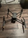
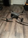
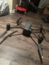
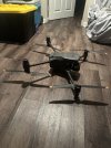
DDroneTecLLC replied to the thread Wanted: Mavic 3 Thermal.I have a Matrice 30T for sale if you're interested.
-
DFor sale I have a DJI Matrice 30T drone. Roughly 24hrs of flight time. With it I have the hard rolling case, RC Plus controller, 4 - TB30 Intelligent flight batteries, and BS30 Intelligent Charging Station. I am located in Jackson, MI. The drone...
-
-
Jjaja6009 reacted to adm_geomatics's post in the thread Photogrammetric processing of a shaded valley floor with Like.
I'll add to @Dave Pitman 's great advice in that this would be one of those times appropriate for image editing. I use ACDSee to batch correct image exposure while maintaining the geotags containing the RTK geotags and accuracy properties. I have...
-
SSteveBCH replied to the thread Photogrammetric processing of a shaded valley floor.Interesting. I'll look into that. Thanks!
-
adm_geomatics replied to the thread Photogrammetric processing of a shaded valley floor.I'll add to @Dave Pitman 's great advice in that this would be one of those times appropriate for image editing. I use ACDSee to batch correct image exposure while maintaining the geotags containing the RTK geotags and accuracy properties. I have...
-
SSteveBCH replied to the thread Photogrammetric processing of a shaded valley floor.Got it. Thanks!!