- Joined
- Nov 14, 2018
- Messages
- 1
- Reaction score
- 0
- Age
- 36
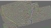
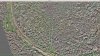
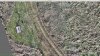
I am using a DJI Mavic Pro for mapping an 80 acre parcel. I am using Pix4D to plan the flight and using MapsMadeEasy to create the map. I have attempted to make this map several times and there always seems to be an issue with blurring, gaps, smearing,...etc. Looking for any tips to become a better mapper. I am using 90% overlap flying at 400 ft altitude at normal flying speed.