

Hi Everyone,
I am an amateur videographer who received my Part 107 license in December 2017. FYI, I applied for Airspace Authorization in January 2018 for the local airport (KGUC) Surface E airspace and last week received a 4 month authorization. The authorization specified I comply with the maximum height restrictions in the UAS air facilities map and expires 9/30/18. I assume & hope the authorization’s 9/30 expiration coincides with nationwide LAANC availability. But I digress. I have a case study I’d like those with more knowledge than I to consider.
A local semi-government/chamber-of-commerce type organization hired a production company (including a Part 107 pilot) to produce a video of mountain biking on local trails as part of their ongoing efforts to promote the area. I believe the aerial/video shoot I’m writing about took place on 5/15/2018.
While I’d like to think the project was handled legally & professionally, it looks to me to not completely be the case. This is why I’m asking the community to clarify if I understand the rules correctly (or not.)
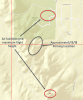
The 5/15/18 filming location was on a mountain bike trail within the Surface E airspace of the local airport (KGUC) during airport operational hours. KGUC is a non-towered airport operational between 0600 – 2230 local time. Sunrise is about 5:55 am this time of year. The filming location on 5/15/2018 appears to be within both 100’ and 0’ (no-fly) grids on the UAS air facilities map. I believe those grids, while relevant to my authorization, are irrelevant to this case as this case appears to involve completely unauthorized UAS flights. Prior shoots were also in the Surface E airspace and I presume operated with a similar level of rules knowledge and authorization as the 5/15 shoot.

Someone I know was part of the 5/15/18 shoot. Previously, we had discussed the requirements to fly UAS in the KGUC Surface E over the bike trails, my unwillingness to fly until my authorization request was approved, and my impatience as I awaited the approval. He was interested in what I was up to and had casually asked many questions about the regulations. It was when I received my authorization approval and emailed him with the good news that I learned about this shoot that occurred the previous day.
My friend said when they arrived & prepared to film, the pilot and crew appeared to have their ducks in a row. They had commercial filming permits from both the Bureau of Land Management (BLM) & the local city (Gunnison, CO). My friend tells me he asked if they had FAA permission to fly near the airport as he knew about my 5 month wait for the FAA airspace authorization. My friend said someone with the production company (I assume the Part 107 pilot) told him they didn’t need FAA approval to fly there. But then saw fit to call the local airport “to confirm.” In that call they were told as long as they stayed under a certain height they were fine. Anyone taking a look at the sectional map would see the dashed magenta circle around the airport denoting SFC E airspace.
I question how a Part 107 pilot could be that close to an airport and not know his airspace. Then assert "no FAA permission needed here" as if he did know. Then ask a local airport person (non-FAA) for airspace knowledge and then rely on that for a commercial operation. Yikes! Appears to me either the pilots were absolutely clueless about airspace designations (and their Part 107 certificate knowledge responsibilities) or hoping they could get by without anyone noticing. My money is on the latter. . .
My brother (both a private & part 107 pilot) is an airport manager at a busy airport in a distant state. He tells me he doesn’t have authority to grant airspace permissions. He goes on to say he certainly welcomes & accepts notifications from hobby pilots and appreciates the courtesy of a head’s up from the Part 107 ones.
Bottom line is that my understanding from my Part 107 studies was the magenta dashed circle identifies Surface E during airport operation hours (clearly noted in the legend of a sectional chart) and specific FAA authorization is required for Part 107 flights in Surface E; that's not subject to any interpretation - it's black & white. Of course I could be badly misunderstanding the rules in which case I’ll eat my crow – please pass the hot sauce. But that is why I’m posting this. I welcome the education and it seems a good case for the community to discuss.
Thanks for your comments,
Steve
I am an amateur videographer who received my Part 107 license in December 2017. FYI, I applied for Airspace Authorization in January 2018 for the local airport (KGUC) Surface E airspace and last week received a 4 month authorization. The authorization specified I comply with the maximum height restrictions in the UAS air facilities map and expires 9/30/18. I assume & hope the authorization’s 9/30 expiration coincides with nationwide LAANC availability. But I digress. I have a case study I’d like those with more knowledge than I to consider.
A local semi-government/chamber-of-commerce type organization hired a production company (including a Part 107 pilot) to produce a video of mountain biking on local trails as part of their ongoing efforts to promote the area. I believe the aerial/video shoot I’m writing about took place on 5/15/2018.
While I’d like to think the project was handled legally & professionally, it looks to me to not completely be the case. This is why I’m asking the community to clarify if I understand the rules correctly (or not.)
The 5/15/18 filming location was on a mountain bike trail within the Surface E airspace of the local airport (KGUC) during airport operational hours. KGUC is a non-towered airport operational between 0600 – 2230 local time. Sunrise is about 5:55 am this time of year. The filming location on 5/15/2018 appears to be within both 100’ and 0’ (no-fly) grids on the UAS air facilities map. I believe those grids, while relevant to my authorization, are irrelevant to this case as this case appears to involve completely unauthorized UAS flights. Prior shoots were also in the Surface E airspace and I presume operated with a similar level of rules knowledge and authorization as the 5/15 shoot.
Someone I know was part of the 5/15/18 shoot. Previously, we had discussed the requirements to fly UAS in the KGUC Surface E over the bike trails, my unwillingness to fly until my authorization request was approved, and my impatience as I awaited the approval. He was interested in what I was up to and had casually asked many questions about the regulations. It was when I received my authorization approval and emailed him with the good news that I learned about this shoot that occurred the previous day.
My friend said when they arrived & prepared to film, the pilot and crew appeared to have their ducks in a row. They had commercial filming permits from both the Bureau of Land Management (BLM) & the local city (Gunnison, CO). My friend tells me he asked if they had FAA permission to fly near the airport as he knew about my 5 month wait for the FAA airspace authorization. My friend said someone with the production company (I assume the Part 107 pilot) told him they didn’t need FAA approval to fly there. But then saw fit to call the local airport “to confirm.” In that call they were told as long as they stayed under a certain height they were fine. Anyone taking a look at the sectional map would see the dashed magenta circle around the airport denoting SFC E airspace.
I question how a Part 107 pilot could be that close to an airport and not know his airspace. Then assert "no FAA permission needed here" as if he did know. Then ask a local airport person (non-FAA) for airspace knowledge and then rely on that for a commercial operation. Yikes! Appears to me either the pilots were absolutely clueless about airspace designations (and their Part 107 certificate knowledge responsibilities) or hoping they could get by without anyone noticing. My money is on the latter. . .
My brother (both a private & part 107 pilot) is an airport manager at a busy airport in a distant state. He tells me he doesn’t have authority to grant airspace permissions. He goes on to say he certainly welcomes & accepts notifications from hobby pilots and appreciates the courtesy of a head’s up from the Part 107 ones.
Bottom line is that my understanding from my Part 107 studies was the magenta dashed circle identifies Surface E during airport operation hours (clearly noted in the legend of a sectional chart) and specific FAA authorization is required for Part 107 flights in Surface E; that's not subject to any interpretation - it's black & white. Of course I could be badly misunderstanding the rules in which case I’ll eat my crow – please pass the hot sauce. But that is why I’m posting this. I welcome the education and it seems a good case for the community to discuss.
Thanks for your comments,
Steve
Attachments
Last edited:

")


