Hello,
I'm an experienced Level 1 building thermographer from The Netherlands and my company is currently looking into getting a drone based camera to do roof and high rise inspections. We might move into the high voltage electrical inspections and other commercial fields with it too.
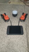
To start out, we are currently looking into the DJI Mavic 2 Enterprise Advanced and getting all the required licenses.
I have been working with FLIR B335, B365 and T640bx camera's for over 12 years and we will probably upgrade to T10XX series soon, so I am used to having quite good quality thermal imaging tools.
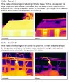
How do these enterprise level drones with thermal imaging capabilities hold up against camera's like the T640bx? The drone is "enterprise level" but going by the prices I expect the thermal imaging capabilities to be a lot lower than my handheld camera. The resolution is there, but how do the other parameters compare? Our climate is pretty mild, so we are working with small temperature differences most of the time. Is it possible to do live analysis with these as I can do on my camera or can that only be done afterwards with tools like FLIR Tools?
Thanks in advance!
I'm an experienced Level 1 building thermographer from The Netherlands and my company is currently looking into getting a drone based camera to do roof and high rise inspections. We might move into the high voltage electrical inspections and other commercial fields with it too.
To start out, we are currently looking into the DJI Mavic 2 Enterprise Advanced and getting all the required licenses.
I have been working with FLIR B335, B365 and T640bx camera's for over 12 years and we will probably upgrade to T10XX series soon, so I am used to having quite good quality thermal imaging tools.
How do these enterprise level drones with thermal imaging capabilities hold up against camera's like the T640bx? The drone is "enterprise level" but going by the prices I expect the thermal imaging capabilities to be a lot lower than my handheld camera. The resolution is there, but how do the other parameters compare? Our climate is pretty mild, so we are working with small temperature differences most of the time. Is it possible to do live analysis with these as I can do on my camera or can that only be done afterwards with tools like FLIR Tools?
Thanks in advance!