Welcome, Commercial Drone Pilots!
Join our growing community today!
Sign up

Ground Station Pro

RNCotton

Well-Known Member
Joined
Jan 17, 2018
Messages
94
Reaction score
43
Age
51
Location
Memphis, TN
Website
www.rogercotton.com
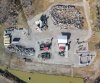
Am I missing something here? We're still learning all the cool stuff, and I used GS Pro to plan a flight mission to photograph our Search and Rescue rubble pile training facility. (AKA, my drone playground) The mission flew great and we got a series of photos to stitch together to make a large image.

I used Lightroom to do my stitching. I also used the native GS Pro compositing tool. Once GS Pro was done, it brought the stitched imagery into the map. But ... can I not export / save that composited image? Is it only just for use within the GS Pro software? I didn't see anything that lets me save it out, and I looked through the manual as well for clues.

Image stitch from Lightroom attached just for giggles. Flight was from 200 feet because 150 feet generated more than 99 waypoints, which is GS Pro's limit.
 

Attachments

  • RubblePile_MedRez_02-09-18.jpg
    RubblePile_MedRez_02-09-18.jpg
    1.9 MB · Views: 79
I don’t remember how to do it off the bat, but I’ve saved them to my computer....
 
LR seemed to do a nice job for you. There are also other stitching services you can subscribe to. Most are fairly common and well known, but if you need some ideas just let us know. We have clients using most all of them.
 
Does light room do proper stitching like other mapping software? I pay for it with CC and never really use it so this is very interesting?

Thanks
Mick
 
I think your issue is in using Lightroom. When I use Drone Deploy or Maps Made Easy they do the stitching and return a usable file. I have taken the file to Staples and have had 48x48 prints made. Also, you can specify the file type, Jpeg, Tif., etc.
 
  • Like
Reactions: BigAl07
Does light room do proper stitching like other mapping software? I pay for it with CC and never really use it so this is very interesting?

It's a "panoramic" ... but LR doesn't care if it's 3 photos side by side, or 70 photos top-down. It just looks for overlaps, aligns, and blends.
 
I think your issue is in using Lightroom. When I use Drone Deploy or Maps Made Easy they do the stitching and return a usable file. I have taken the file to Staples and have had 48x48 prints made. Also, you can specify the file type, Jpeg, Tif., etc.


Oh, I've got a perfectly usable file from Lightroom. It's "MegaRez" and I've got a 44" print hanging on my wall now. I've used this method to print wallpaper before. "One Photo" turned into 20' x 30' wallpaper at a museum. Built from multiple images, stitched in Lightroom.

My question was if GS Pro would output the file it made, or if GS Pro only used the composite internal for it's own mapping view.


I am not sure RN, I have never used DJI Ground Station. I don't know how it interacts with Lightroom.
 
I am not sure RN, I have never used DJI Ground Station. I don't know how it interacts with Lightroom.


It doesn't interact at all with LR. I just copy the photos from the card to the computer and turn LR loose with it. I wanted to compare how well of a job LR does with what GSP puts out. But, I can't figure out how to export / save the composite from GSP
 
It doesn't interact at all with LR. I just copy the photos from the card to the computer and turn LR loose with it. I wanted to compare how well of a job LR does with what GSP puts out. But, I can't figure out how to export / save the composite from GSP

Thankyou for raising this discussion. You have potentially saved us alot of money for a mapping project we have coming up. Is it difficult to stitch in LR?
 
As long as your images have overlap, Lightroom handles the stitching easily. You load your images, select them, then tell LR to make a panoramic. For 70 images, it took about 15 minutes for my computer to crunch it.

That sounds ideal thanks as i could just fly a mission on Drone deploy and stitch it up easily. I try and fly 80% overlap if i can.
 
I see where DJI has included PhotoMap into GS Pro. Its a stitching tool. Was offered when I recently updated the app. It will stitch together, but kept crashing and even says you may need to limit the number of pics or IOS may crash. What?

Sure enough, I did about 20 photos and after that it kept crashing. Even with two pics. Seems like they give you 5 freebies and then you must purchase the option. Would hope a free preview of the app worked 100%, but it didn’t. $299 for PhotoMap!!!!

The pics it did looked good.
 
Last edited:
I see where DJI has included PhotoMap into GS Pro. Its a stitching tool. Was offered when I recently updated the app. It will stitch together, but kept crashing and even says you may need to limit the number of pics or IOS may crash. What?

Sure enough, I did about 20 photos and after that it kept crashing. Even with two pics. Seems like they give you 5 freebies and then you must purchase the option. Would hope a free preview of the app worked 100%, but it didn’t. $299 for PhotoMap!!!!

The pics it did looked good.

I personally would do everything as far as possible away from Dji software anyway. Its absolutely appalling in everything they do. If they didnt have good hardware they would be long gone as its their one area of brilliance.

The amount of issues i have had in 12 months of updates and times i have had real problematic issues as a result is ridiculous.
 
Does light room do proper stitching like other mapping software? I pay for it with CC and never really use it so this is very interesting?

Thanks
Mick

I've used LR to stitch together photos taken with GS Pro. The biggest difference between something like Agisoft PhotoScan and LR is that with LR you gt a 2D image instead of a 3D image.
 
I've used LR to stitch together photos taken with GS Pro. The biggest difference between something like Agisoft PhotoScan and LR is that with LR you gt a 2D image instead of a 3D image.

Yeah but i had never even considered it as a platform for stitching anything together so i am still happy. Its a shame you can not get any form of scale on there as it would of been ideal for alot of measure jobs etc.

I always find i play around less with mapping purely because stitching software costs are so high and we dont use it often enough to buy a full years sub.

A free 3d generating platform, now that would be a winner :)
 
Last edited:
Yeah but i had never even considered it as a platform for stitching anything together so i am still happy. Its a shame you can not get any form of scale on there as it would of been ideal for alot of measure jobs etc.

I always find i play around less with mapping purely because stitching software costs are so high and we dont use it often enough to buy a full years sub.

A free 3d generating platform, now that would be a winner :)
There's one called OpenDroneMap, but it's designed more for software developers than DroneDeploy/pix4d/et al.
 

Members online

No members online now.

Forum statistics

Threads
4,277
Messages
37,605
Members
5,969
Latest member
KC5JIM