Welcome, Commercial Drone Pilots!
Join our growing community today!
Sign up

Imposing lines/boundaries in Litchi Mission Hub

BigAl07

Administrator
Staff Member
Premium Pilot
DSAR Member
Joined
Jan 8, 2018
Messages
2,817
Reaction score
2,531
Age
53
Location
Western North Carolina
Long shot here but here goes:

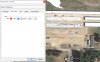
I'm going to be working on a long-term construction project that's a couple of hours drive from my office. I need to pre-plan as much as I can before driving to the job site so I'm tinkering with some flights using Litchi in the Mission Hub (browser based interface not on tablet) but the problem is the map that Litchi is using is slightly out of date and a couple of the buildings that are UP now on the job are not showing on the map. I'd like to "locate" them on the Mission Hub so I can incorporate their position into my flight planning.

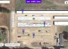
Also the very center of my project and the access road around the project are not showing and I need to incorporate them into my planning. I have a detailed picture that I just snapped of the job site so I should be able to approximate where to place the boundaries but is there a way within Litchi to add these for "reference only"?

I'm open to suggestions and of course "alternatives" but I need to be able to preplan and prefly my missions for make this project work long-term. I'll need to make some complex flights here and there so the ability to use waypoints and POI will be a must.
 
  • Like
Reactions: dirkclod
Hi Al, You can use Google Earth and using your planning photographs, draw a path (for example) and save that as a .kml file. You can then import that into Litchi as a new mission and adjust as needed.
 

Attachments

  • 1.JPG
    1.JPG
    326.3 KB · Views: 16
  • 2.JPG
    2.JPG
    343 KB · Views: 16
  • Like
Reactions: dxtrty and BigAl07
Hi Al, You can use Google Earth and using your planning photographs, draw a path (for example) and save that as a .kml file. You can then import that into Litchi as a new mission and adjust as needed.

Great idea Dave. Is there a way to impose my photograph(JPG) over the image in GE to use as a template to draw the landmarks accurately?
 
Try flying your mission in google earth. Program it first in litchi then test fly it before you go. Explained more here Virtual Litchi Mission


Thanks Mark. That's exactly what we've been doing but the construction site has changed significantly since the last Google Earth pic was taken and we needed the most recent images possible in order to be able to have an accurate and SAFE flight path. That's why we used an image we had just taken and with help from @Dave Pitman were able to overlay it onto GEP.

Look at this post from that very thread to see why it needed to be as current as possible:
Virtual Litchi Mission

I'm attaching the flight path from GEP to show what we are doing:
Hendo_Spiral_DOWN.jpg
 
i'm very happy to see that someone else is using curved flight lines to a) provide a superior diversity of views and b) mitigate the SfM doming (elevation) error experienced when traditional (linear/parallel) flight lines are used. Refer to the following independent research:

Are we still limited to 99 waypoints? Not so good for curved flight lines which a) give you a superior diversity of views and b) mitigate the systematic SfM doming (elevation) error - especially when oblique imagery is included. Refer to the following independent research:

Minimising systematic error surfaces in digital elevation models using oblique convergent imagery
Rene Wackrow

Jim H. Chandler
First published: 16 March 2011

https://doi.org/10.1111/j.1477-9730.2011.00623.x

Results of the simulation process, the laboratory test and the practical test are reported in this paper and demonstrate that an oblique convergent image configuration eradicates the systematic error surfaces which result from inaccurate lens distortion parameters. This approach is significant because by removing the need for an accurate lens model it effectively improves the accuracies of digital surface representations derived using consumer‐grade digital cameras. Carefully selected image configurations could therefore provide new opportunities for improving the quality of photogrammetrically acquired data.

You can get a visual comparison between the effectiveness of using curved flight lines vs traditional (linear/parallel) flight lines from the two attached images for a very large area.
 

Attachments

  • Log-spiral flight lines.jpg
    Log-spiral flight lines.jpg
    307.1 KB · Views: 3
  • Fairbanks Fodar flight lines.jpg
    Fairbanks Fodar flight lines.jpg
    456.8 KB · Views: 3

Members online

No members online now.

Forum statistics

Threads
4,294
Messages
37,668
Members
5,993
Latest member
Roy thellmann