Welcome, Commercial Drone Pilots!
Join our growing community today!
Sign up

Is anyone measuring the volume of concrete being poured into new home construction foundations and comparing them to take off plans?

WickedRedux

New Member
Joined
Dec 20, 2018
Messages
2
Reaction score
0
Age
39
Hello everyone. First post here.

Before I receive answer's for this specific question let me please fill you on with what was asked of me and a brief background history. I work for a 3rd party quality control inspection company as a UAV operator. My usual task are to do final roof inspections, 3D Models, Photo and video Marketing and editing. Occasionally I will use our DroneDeploy business account to do volume-metrics. Our clients typically do not request calculations. However, two days ago our client (A home builder company) asked us if we could examine the footing depth versus the foundation concrete that's poured to provide accurate measurements. There are a few reasons as to why they want to do this. One being they want to make sure footings are not over dug. Two being they usually accept the concrete pour tickets with no real way to check. and three there is no point in paying for excess material when its not called for in the plans of the foundation. Now that you may have a brief oversight of the situation and understanding here comes the question.

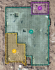
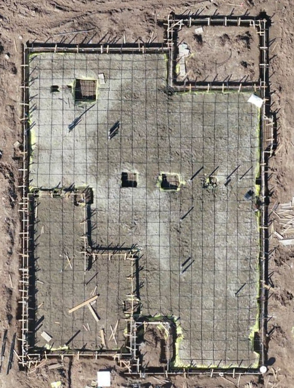
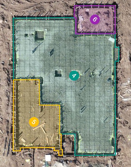
Is anyone in the industry doing these calculations? I would like a better understanding when measuring the volumes (negatively) because I am trying to get the depth from dronedeploy by putting the area fence on the forms. with metal and post tension on my maps I would say I'm getting close but I'm about 5 cubic yards off from exact plans. If I can dial this in or figure out the best time to measure (perhaps its better without post tension cables and metal in maps) we could fulfill the service requested. Below are attached pictures showing one of the sites that I am trying to measure, pre-foundation pour. In laymen's terms, I just need a way to measure how much material will be used to fill this hole and if there is a perfect window of opportunity to accomplish this task.

Site with forms, post tension cables and metal.
57_site-jpg.106486
57-jpg.106487
 

Attachments

  • 1545350601098.png
    1545350601098.png
    538.3 KB · Views: 10
Welcome to the forum.

I see a couple of problems. In volumetrics, 5% variance between distinct calculations are normal. Add to that having a complex topography subject like the footing/slab presents would probably increase the variance.

I would think with less time and expense, you you could walk around the form and spot check depths with a tape measure to compare with the plan depths. Not as sexy but probably more accurate and cost effective.
 
Welcome to the forum.

As @Dave Pitman suggests a sUAS is probably not the right tool for this particular job. As much as we would all love to change the world (industry) with our sUAS there are many times/situations where a sUAS is just not the right tool. It' up to us to know which tool is the most accurate/efficient/cost effective for each job/task at hand.
 
Thanks and truly appreciate the time and replies @BigAl07 & @Dave Pitman

While I agree with both of your inputs keep in mind drones were adapted into the construction industry to measure and calculate volumes right? Now I'm not trying to change the world I'm trying to help builders by providing quality control and assurance and overall to help them save $$ money. Imagine pouring an extra 5 cubic yards into a foundation and 1 cubic yard cost roughly $150. 150 x 5 = $750 multiply that to a track of homes a builder is building and lets say there is 450 homes just in one project. lets multiple $750 x 450 foundations/homes that's an extra $337,500 dollars that has now been added to the project and that's just 1 project for this particular builder. Even If there was a standard variance we could factor in all the time, that could still help me calculate measurements. And Yes Dave technically spot checking depths and using an average would possibly be a tad more accurate but IT couldn't be more efficient flying a drone and taking measurements. Its also up to us to test and push boundaries and not be stuck inside the box.
 
Last edited:
Thanks and truly appreciate the time and replies @BigAl07 & @Dave Pitman

While I agree with both of your inputs keep in mind drones were adapted into the construction industry to measure and calculate volumes right? Now I'm not trying to change the world I'm trying to help builders by providing quality control and assurance and overall to help them save $$ money. Imagine pouring an extra 5 cubic yards into a foundation and 1 cubic yard cost roughly $150. 150 x 5 = $750 multiply that to a track of homes a builder is building and lets say there is 450 homes just in one project. lets multiple $750 x 450 foundations/homes that's an extra $337,500 dollars that has now been added to the project and that's just 1 project for this particular builder. Even If there was a standard variance we could factor in all the time, that could still help me calculate measurements. And Yes Dave technically spot checking depths and using an average would possibly be a tad more accurate but IT couldn't be more efficient flying a drone and taking measurements. Its also up to us to test and push boundaries and not be stuck inside the box.
Well, if you want to try it, just do it. You have a method immediately at hand to check the accuracy of the drone work; and I would definitely check it - as in "making a list and checking it twice". You could easily ruin your drone reputation with erroneous results being conveyed to your customer. BEaWARE of the systematic SfM doming (elevation) error if you are using straight, parallel flight lines to photograph the sites - even though they are small. You might want to use curved flight lines to mitigate the SfM doming error; and you might want to use GCPs to qualify your horizontal and vertical accuracy. If you are going into the professional realm, then be professional. I'm attaching a couple of files to illustrate the use of curved flight lines. Good luck! By the way, in the examples provided, there are no parallel line segments anywhere in the area being mapped. All photographs captured will have a slightly different orientation; because the curves are all logarithmic-spiral curve segments tangent to selective short circular arc segments - each with a different radius. There are no turn-out loops for fixed-wing aircraft (drones) to expend wasted flight time or battery life on. Think about it.
 

Attachments

  • Pebble Creek Mine Image.jpg
    Pebble Creek Mine Image.jpg
    1.2 MB · Views: 25
Welcome to the forum.

I see a couple of problems. In volumetrics, 5% variance between distinct calculations are normal. Add to that having a complex topography subject like the footing/slab presents would probably increase the variance.

I would think with less time and expense, you you could walk around the form and spot check depths with a tape measure to compare with the plan depths. Not as sexy but probably more accurate and cost effective.

Completely agree with the above. As a previous general contractor the common practice is to verify form dimensions with plans. Volume is easily established by counting the number of form risers. One 2x6 high, two 2x6 high, etc. Footings are dug to depths required for the number of stories. Rebar height is always consistent.

If a penny pincher outfit is going to use drone derived volume estimates the drone operator needs to be **** sure their numbers are accurate to less than a single percentage point else they end up named as a defendant in the civil suit brought by the material supplier.

Ready mix outfits know to the pound what went out in the truck and how much slurry came back in the truck, and calculating ready mix volume by weight and converting to yards based on pour weight is very easy to do at high accuracy levels.
 
  • Like
Reactions: AH-1G
a 5% and even an 8% error already indicate it to you the own programs. It could be perfect if the base, the lowest level from where you start to calculate the volume is completely flat. If this is not the case, the error is guaranteed.
 
The answer to your question lies in the similar concept to doing stock pile VM. If your project requires a high degree of global accuracy you will need the aid from land surveyors to establish true and accurate ground control points . The drone is just a supporting tool in achieving complementary measurements.
 
  • Like
Reactions: BigAl07

Members online

No members online now.

Forum statistics

Threads
4,277
Messages
37,605
Members
5,969
Latest member
KC5JIM