Welcome, Commercial Drone Pilots!
Join our growing community today!
Sign up

LAANC / Max Altitude / Takeoff Ground Elevation

ChrisPCritter

New Member
Joined
Mar 9, 2019
Messages
2
Reaction score
1
Age
70
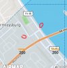
Question regarding LAANC altitude limit and launch locations for planning purposes.
Example (see graphic): Class D airspace, 200' limit AGL in this quadrant. You are launching from river's edge and requested 150' max altitude via LAANC. Fly around the river not exceeding your 150' AGL authorization.
Next, launching several blocks inland from river, from a hill 100' higher than the river launch. Again request 150' from LAANC. Launch straight up to 150' AGL, then VLOS straight over to the river. At this point, are you 250' AGL above the river and exceeding your LAANC restrictions?
Thanks in advance, I'm usually flying over flat terrain and Class G , so normally not a problem
 

Attachments

  • airspace.jpg
    airspace.jpg
    160.3 KB · Views: 14
Your AGL is the piece of land directly under your aircraft. Your launch point is 'technically" a moot point except you need to know that the Launch Point is your aircraft's altitude reference point.

If you launch from a 100' hill, ascend to 150' AGL and fly laterally over ground that is reducing elevation you are immediately violating your authorization.
 
Good info, thank you BigAl. For flight planning in these types of scenarios, if someone is planning on using all of their LAANC-approved altitude, then it seems prudent to apply for a launch area where there's not too much downhill terrain in their lateral flight path !?!
 
  • Like
Reactions: BigAl07
Good info, thank you BigAl. For flight planning in these types of scenarios, if someone is planning on using all of their LAANC-approved altitude, then it seems prudent to apply for a launch area where there's not too much downhill terrain in their lateral flight path !?!

That, or have terrain following. You want to make sure you have a buffer from the ceiling as well. Your RTH altitude "should" exceed the maximum obstruction height for that grid if you are flying in close proximity to it. Otherwise, you risk a collision in a worst case scenario.
 
Good info, thank you BigAl. For flight planning in these types of scenarios, if someone is planning on using all of their LAANC-approved altitude, then it seems prudent to apply for a launch area where there's not too much downhill terrain in their lateral flight path !?!


If that's possible but where I fly (Mountains of Western North Carolina) we don't have much option other than pretty much trying to fly/launch in about the same area.

I flew in a 100' Custom Authorization (it was a ZERO AGL quadrant) and I couldn't fly over top of the trees from one location to another. While I find it silly that I couldn't go to 125 to clear the trees I still followed my Authorization to a "T" and still made the $$ at the end of the day.
 
Good information to know. I didn't think I would be able to get authorization with a 0 AGL quadrant.
 
"Good information to know. I didn't think I would be able to get authorization with a 0 AGL quadrant."

I've gotten a couple in 0 quad areas. If you take the time to go over everything you will do to mitigate the dangers - VO's, CT/CTAF radio monitoring, flight apps to monitor what planes are in the area, two way communications on the job site, mic extenders that can clip on to the pilot's lapel to keep you hands free but able to respond to steering commands, the type of geo-fencing you will be using, even include having a first aid kit and fire extinguisher at the pilot or VO location, that sort of thing - then the FAA will bend every effort to help you with the authorization. Under-prepared pilots that just say they want to fly but have no clue (or no indicators listed) as to what the risks are and what they intend to do to mitigate them will usually get denied. My last authorization process took approximately 3 weeks to get from the day I filed, but they can take the full 90 days depending on the workload where you are filing and the intricacies of the location needed. Just have a good game plan and be ready to list everything. Most of the guys (and gals) I've worked with at the FAA are really trying their best to make the drone community feel welcome.
 
  • Like
Reactions: BigAl07
So far every request I've made has been within the AGL limits for that quadrant. I mistakenly assumed that if the limit was 0 I could not even request a waiver
 
Common mistake. You can, but it does take a LOT of preparation. The FAA utilizes the Zero quadrants to basically encompass the approach corridor for the runways (other reasons exist, but this is most common usage). The closer to the airport you are, the tighter this level gets (plane is descending/ascending). So right next to the threshold you might not get authorized for 100 feet (although you might, depending) where as further out the mitigation offered might be deemed sufficient at your requested altitude. They might, for instance, utilize another runway during your operating hours if one is available. You may request an authorization (drone zone only, not through LAANC) for any level above the posted quadrant level up to the 400 feet maximum. Doesn't mean you'll get it, but it is an available option.
 
  • Like
Reactions: BigAl07

Members online

No members online now.

Forum statistics

Threads
4,291
Messages
37,659
Members
5,992
Latest member
GerardH143