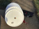
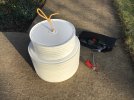
GCPs are points (targets) on the ground that are surveyed and visible in the aerial photos. I use white 5-gal bucket lids as GCP targets. I‘ve drilled a hole in the center of the lids so I can pin them to the ground with a large nail and carry them in a stack on a “stringer“ I made. The heads of the nails or holes in the lids are often visible in the photos, which helps us enter coordinates of the GCPs in the photo processing software. We survey the coordinates of the GCPs using RTK GPS or other survey instruments (robotic total station, etc.). You can also use painted GCPs, prominent features that appear in the photos, etc., but you need to survey or know the location of all GCPs. There are also commercially made GCP targets that have RTK GPS receivers built into them but they are expensive and I wonder about their ability to “see” the sky/GPS satellites when sitting on the ground.
GCPs are necessary for best accuracy of an aerial survey because they allow the processing software to correct distortions that may be in the photos/photo mosaic from various sources. An RTK GPS receiver on the aircraft also improves accuracy of the survey by providing better locations of the photographs, but you need GCPs to correct for other errors such as distortions caused by the camera lens, and camera movement and tilt that are too small for the sensors on the aircraft to resolve and record. I use GCPs and no RTK on the aircraft all the time.


 Sharing My Music and Sound Effects - Over 2000 Tracks
