Welcome, Commercial Drone Pilots!
Join our growing community today!
Sign up

Reading sectional for Special use airspace

codejoy

New Member
Joined
May 8, 2019
Messages
4
Reaction score
2
Age
45
I have my b4ufly app, and it says entire towns near me not to fly. Though I double check the sectionals and it is special use defined by the following codes:

R-5109A
R-5017F
R-5107G

But other R- numbers are on sectionals but not the above ones?

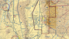
The areas are on here:


over the cities of Alamogordo NM and Ruidoso NM.

Is there somewhere I can go and read up on these to find out if I can fly or not, I thought the sectionals were supposed to provide additional information but it seemed difficult to discern if there was a time I could fly in these zones. Any help on cracking this would be awesome.
 
You would probably do well to go to your local Flight School and sign up for an hour of instruction specifically on interpreting the sectionals in your area. Once it "clicks" it gets a lot easier but even after years of reading them I still get stumped more often than I care to admit :)

Welcome to the forum.
 
  • Like
Reactions: LUIS MARTINEZ
I have my b4ufly app, and it says entire towns near me not to fly. Though I double check the sectionals and it is special use defined by the following codes:

R-5109A
R-5017F
R-5107G

over the cities of Alamogordo NM and Ruidoso NM.

Is there somewhere I can go and read up on these to find out if I can fly or not, I thought the sectionals were supposed to provide additional information but it seemed difficult to discern if there was a time I could fly in these zones. Any help on cracking this would be awesome.

First off, do not rely on an app to give you accurate information. That is the reason the FAA publishes sectional charts and other navigation aids. They are the source for aeronautical information. The rest are unreliable. That is the reason the FAA placed so much emphasis on learning to read a sectional chart and it was on the test numerous times.
Ruidoso falls under the Beak B MOA. Alamogordo proper is either Class D or Class E airspace unless you stray farther east which falls under another MOA or farther west which falls under restricted airspace (White Sands complex). Like @BigAl07 suggested, sign up for some instruction and learn to read the charts.
 
  • Like
Reactions: BigAl07
First off, do not rely on an app to give you accurate information. That is the reason the FAA publishes sectional charts and other navigation aids. They are the source for aeronautical information. The rest are unreliable. That is the reason the FAA placed so much emphasis on learning to read a sectional chart and it was on the test numerous times.
Ruidoso falls under the Beak B MOA. Alamogordo proper is either Class D or Class E airspace unless you stray farther east which falls under another MOA or farther west which falls under restricted airspace (White Sands complex). Like @BigAl07 suggested, sign up for some instruction and learn to read the charts.
Double thumbs up! Gotta learn Sectionals to operate safely in the aviation business. This may help.

 
Last edited:
  • Like
Reactions: BigAl07
First off, do not rely on an app to give you accurate information. That is the reason the FAA publishes sectional charts and other navigation aids. They are the source for aeronautical information. The rest are unreliable. That is the reason the FAA placed so much emphasis on learning to read a sectional chart and it was on the test numerous times.
Ruidoso falls under the Beak B MOA. Alamogordo proper is either Class D or Class E airspace unless you stray farther east which falls under another MOA or farther west which falls under restricted airspace (White Sands complex). Like @BigAl07 suggested, sign up for some instruction and learn to read the charts.

I thought the b4ufly app was published by the FAA? It seemed like the app contradicted the sectionals. Reading the sectionals isn't too difficult, though I don't do it enough to make it second nature. I was pretty stumped since there was no notes on the above flight areas that I saw and googling the areas gave me general but no specifics (I thought R was restricted but possibly on schedule which is what I was looking for, I didn't think it was active all the time).
 
  • Like
Reactions: Taosi and BigAl07
I thought the b4ufly app was published by the FAA? It seemed like the app contradicted the sectionals. Reading the sectionals isn't too difficult, though I don't do it enough to make it second nature. I was pretty stumped since there was no notes on the above flight areas that I saw and googling the areas gave me general but no specifics (I thought R was restricted but possibly on schedule which is what I was looking for, I didn't think it was active all the time).

"The Federal Aviation Administration (FAA) has partnered with Kittyhawk to redevelop B4UFLY, the FAA's first mobile application, to improve the user experience so that recreational drone operators know where they can and cannot fly. " Emphasis added by me. Using a sectional should be second nature. They are the most authoritative source for airspace in the US. You cannot rely on short cuts in aviation.
 
  • Like
Reactions: BigAl07
I use skyward, now if you're a recreational flyer you'll have lesser places to fly, unlike having a 107.
@codejoy what town, I'll look at Syward and post Print Screens for you.

Use this, I couldn't open your file.
Also top right;
Layers you can have weather data and other info.

Another App

 
Last edited:
  • Like
Reactions: BigAl07
I use skyward, now if you're a recreational flyer you'll have lesser places to fly, unlike having a 107.
@codejoy what town, I'll look at Syward and post Print Screens for you.

Use this, I couldn't open your file.
Also top right;
Layers you can have weather data and other info.

Another App


Okay I do have a 107, and the towns are Ruidoso, NM and Alamogordo, NM.

I needt o check out Skyward!
 
Where's R-5109A? I need new glasses!

That was near my work, up on a mountain a bit south and east of alamogordo, the b4uflyapp said that one when there, and I couldn't see the restriction anywhere on the sectional. See attached with the red dot.
 

Attachments

  • APOSectional.png
    APOSectional.png
    3.7 MB · Views: 9
That was near my work, up on a mountain a bit south and east of alamogordo, the b4uflyapp said that one when there, and I couldn't see the restriction anywhere on the sectional. See attached with the red dot.
OK, thanks, thought my eyes were going stupid. I couldn't see it on the sectional because it doesn't exist. In aviation, sectionals trump apps. In my 5 years in UAS business I have never even downloaded the b4uwhatever app. Too old to change I guess :p
 
  • Like
Reactions: BigAl07
Supplement your use of the Sectional with the UASFM. (See attached.) While the UASFM is not (currently) included in the 107 written, it is an invaluable tool for UAS pilots as (unlike the Sectional) it can be zoomed all the way in to street level and is designed specifically for operations at or below 400' AGL. In fact, if you apply for a airspace authorization your COA will almost certainly require that you check the UASFM prior to flight ops. (BTW, with 12 options you can even change the base map if you don't like their default choice.)

1314
 
I use the FAA Flight Service portal. It has a new interactive map and all the sectionals are on it. They used to have individual sectionals posted, now it appears the map took their place. Very good cause you can zoom in with a mobile device and it re-focuses! You can build your own dashboard and store your local airports for weather, etc. It has a UAS specific section as well.


Here are some notes on the airspace’s in question.

 
Last edited:
  • Like
Reactions: BigAl07

Members online

No members online now.

Forum statistics

Threads
4,294
Messages
37,668
Members
5,993
Latest member
Roy thellmann