Hello everyone!
Until now I have only been to ParrotPilots and Phantompilots, but I have a larger project coming up.
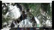
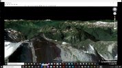
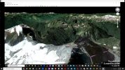
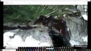
We are planning to map out a large mountain with roughly 0.9-1.5 km² (222 – 370 Acres)
using the DJI Zenmuse P1 35mm mounted on a Matrice 300 RTK to create a 3D Model from it.
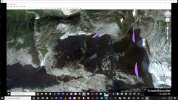
The structure of the mountain is rather complex with all kinds of surfaces: flat, vertical and tilted.
To have an idea of the surfaces I am talking about, compare it to

Kleiner Watzmann or Small Watzmann (Germany)

Mount Triumph (Washington State)

Cerro Torre (Argentina/Chile)
To scan skycrapers and other tall buildings, you can use UGcs, DroneDeploy, Hammer, Dronelink etc.
to preplan vertical and horizontal flights.
Unfortunately, these services do not provide reliable DEMs for mountains. I see three problems with that:
- You do not exactly know where to place the routes, since some elevations are poorly, falsely or not resolved.
- You might end up with a route that has lots of obstacles in it that intervene with the obstacle avoidance system, making the flight useless.
This can even be the slope itself or some larger rocks that were not resolved correctly.
- Your GSD to (esp. for vertical walls) is not consistent, making it harder for the software to create 3D Model, resulting in a suboptimal final product.
A Manual flight seems impossible due to the size of the project.
My solution for all this was to use the Agisoft Metashape Professional workflow, creating a Mission Flight Plan tightly wrapped around an existing or in-situ generated DEM.
Can anyone confirm my idea as feasible or has a better idea? Should we just stick with UGcs? We might also be able to import better satellite derived DEMs into the software.
Cheers and thanks for reading!
SvSz
Until now I have only been to ParrotPilots and Phantompilots, but I have a larger project coming up.
We are planning to map out a large mountain with roughly 0.9-1.5 km² (222 – 370 Acres)
using the DJI Zenmuse P1 35mm mounted on a Matrice 300 RTK to create a 3D Model from it.
The structure of the mountain is rather complex with all kinds of surfaces: flat, vertical and tilted.
To have an idea of the surfaces I am talking about, compare it to
Kleiner Watzmann or Small Watzmann (Germany)
Mount Triumph (Washington State)
Cerro Torre (Argentina/Chile)
To scan skycrapers and other tall buildings, you can use UGcs, DroneDeploy, Hammer, Dronelink etc.
to preplan vertical and horizontal flights.
Unfortunately, these services do not provide reliable DEMs for mountains. I see three problems with that:
- You do not exactly know where to place the routes, since some elevations are poorly, falsely or not resolved.
- You might end up with a route that has lots of obstacles in it that intervene with the obstacle avoidance system, making the flight useless.
This can even be the slope itself or some larger rocks that were not resolved correctly.
- Your GSD to (esp. for vertical walls) is not consistent, making it harder for the software to create 3D Model, resulting in a suboptimal final product.
A Manual flight seems impossible due to the size of the project.
My solution for all this was to use the Agisoft Metashape Professional workflow, creating a Mission Flight Plan tightly wrapped around an existing or in-situ generated DEM.
Can anyone confirm my idea as feasible or has a better idea? Should we just stick with UGcs? We might also be able to import better satellite derived DEMs into the software.
Cheers and thanks for reading!
SvSz