If any one is doing this currently, I would be interested in getting some feedback. I'm currently working on building my product to promote using thermal for commercial roof scans to locate anomalies. Love to hear what anyone is doing.


You are using an out of date browser. It may not display this or other websites correctly.
You should upgrade or use an alternative browser.
You should upgrade or use an alternative browser.
thermal commercial roof scans?
- Thread starter JDL
- Start date
DallasDroneGuy
Member
- Joined
- Feb 1, 2020
- Messages
- 13
- Reaction score
- 2
- Location
- Dallas, Texas
- Website
- www.dallasdroneguy.com
A moisture survey of existing conditions is REQUIRED by all commercial roof system manufacturers before issuing a warranty for a roof overlay using their product. This is to prevent sealing moisture within the roof assembly under the new roof. I say all this to point out that roofing contractors and commercial roof consultants (that's me) are a good place to start when drumming up work. They have several options of which an aerial thermal scan is one. As far as learning technically how to perform this service, i'd recommend you educate yourself quite a bit before having a conversation with potential clients. It is not as simple as it may seem. In what region are you located and what thermal setup do you have?
Pennsylvania, took the level 1 suas course, autel evo 2 dual ( FLIR boson 640x512), been doing several test runs on two local commercial buildings with permission, so far the sensor has quickly picked up obvious anomalies rubber roofing.

DallasDroneGuy
Member
- Joined
- Feb 1, 2020
- Messages
- 13
- Reaction score
- 2
- Location
- Dallas, Texas
- Website
- www.dallasdroneguy.com
Ah, a LOT of EPDM up there. So you're a Level 1 Thermographer!? Nice; you are way ahead of the game already. My turn to ask you for advice. Was it online and how much did it cost? I haven't gotten an employer to pay for it, so I still havent acheived the cert. It is something like $3k each time I have looked into it. I fly Matrice M200 with the Flir XT2.Pennsylvania, took the level 1 suas course, autel evo 2 dual ( FLIR boson 640x512), been doing several test runs on two local commercial buildings with permission, so far the sensor has quickly picked up obvious anomalies rubber roofing.
I got my Level 1 three years ago from Flir at their site in Manchester, NH. Bill Schwan is one of the leaders in the Industry and taught my class. Believe he is working on a Level 2 class now. I spent a year learning on my own before taking the class. There is a lot to learn before you can properly interpret Thermograms with the confidence to put you name to it. Feel free to PM me. I do quite a few commercial low pitch and flat roofs annually. Glad to share my experience.
Dwarkentin
New Member
- Joined
- Mar 20, 2021
- Messages
- 1
- Reaction score
- 0
- Age
- 68
Hi. I am a level 1 thermographer with an Evo @. I am looking at commercial roof scanning as well. I would love to interact with you and maybe lkearn some things about how to proceed. I also own a GPR services company.Pennsylvania, took the level 1 suas course, autel evo 2 dual ( FLIR boson 640x512), been doing several test runs on two local commercial buildings with permission, so far the sensor has quickly picked up obvious anomalies rubber roofing.
Feel free to PM me and I will share my contact information. RegardsHi. I am a level 1 thermographer with an Evo @. I am looking at commercial roof scanning as well. I would love to interact with you and maybe lkearn some things about how to proceed. I also own a GPR services company.
I am not sure. I fly Matrice 200 Series with XT2 sensor for thermal mapping I do. I'd defer to one of the forum Sponsors.Can you conduct automated flights with an autel for thermal mapping?
yes you can!Can you conduct automated flights with an autel for thermal mapping?
yesCan you conduct automated flights with an autel for thermal mapping?
What tool do you use? As I understand, DroneDeploy doesn't support Autel automated flights.
Hawaii Drone Imaging
Well-Known Member
@Hawkwind I also have the EVO Dual 640R. The app has its own mission planning software which will allow you to plan missions and let the drone carry them out. You can also pre download maps of an area and set your mission in case you are in an area with little or no reception from you phone or pad.
I pointed out some other features in a post I replied to here:
 autelpilots.com
I pointed out some other features in a post I replied to here:
Autel Evo 2 Dual 640R quietly appears on a few vendor's sites
I have now saw the Evo 2 Dual 640R for sale on a few vendor's sites. 640 resolution Flir Boson radiometric sensor. Best news $500 more than the regular Dual. The Boson had an extremely long journey to becoming radiometric but it's here and this sensor will mature into a fine product. Flir also...
autelpilots.com
Antroflight
New Member
- Joined
- Feb 4, 2022
- Messages
- 2
- Reaction score
- 1
Don't mean to hijack the thread but can someone recommend a great drone for construction services and specifically IR scans? A good, better, best list perhaps? I was looking at the Mavic 2 enterprise advances with IR but am concerned it's too small. I see @TreeLineView uses the Matrice 200 Series with XT2. DroneDeploy sounds ideal is it a good product for this work? Would love to hear more. Thanks in advance!
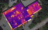
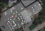
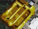
I am very happy with my setup. It does exactly what I need it to do, but it is not cheap. Must have for me, 640 x 512 sensor. 13mm FOV is the best fit for roof and PV array scan and data collection. IMHO. Must be able to take RGB and Thermal image and or video at the same Time. Cuts my fly time in half in many cases. Need to have good solid editing software for thermal post processing. In my opinion, Flir is the leader and nobody is close to their Thermal Studio product to date. I have tried most of the Ortho processing solutions. Landed on DroneDeploy because its easy to use and their AI processing engine is great for thermal Oathos. Disclaimer: Never used Pix4D, so not lumping them in. DD is not cheap. Best one of the best Ortho processing providers for the money is MapMadeEasy. Now offers a Pro subscription which I think is a good deal. MME does not do well with thermal Orthos. Tried and tried and tried. Could not consistently create a usable deliverable. Might be the end user though LOL. Autel is putting the heat on DJI and with their thermal payloads. Very impressive and something to check into. Much cheaper than my setup. Still watching the feedback and how that platform develops. Very promising. @Antroflight, feel free to PM me if you have more questions. Example of couple of Orthos below.Don't mean to hijack the thread but can someone recommend a great drone for construction services and specifically IR scans? A good, better, best list perhaps? I was looking at the Mavic 2 enterprise advances with IR but am concerned it's too small. I see @TreeLineView uses the Matrice 200 Series with XT2. DroneDeploy sounds ideal is it a good product for this work? Would love to hear more. Thanks in advance!
Attachments


New Posts
-

-
 Sharing My Music and Sound Effects - Over 2000 Tracks
- Latest: Eric Matyas