For processing of a non-radiometric orthomap try Reality Capture. It does not need the high overlap that Pix4D does and with its pay as you play purchasing its costs are very low due to the low resolution thermal images (As compared to 20MP images from a Phantom 4 Pro).
Here is my limited experience with different software and hardware.
Drone Deploy
Autel Evo 640T: Not radiometric at this time. Processes as an RGB image, but the details are extremely good! This is from a member on here and Autel Pilots that has been very generous with sharing his in depth testing of the 640T as well as his RTK testing of the Evo 2 RTK aircraft.

www.dronedeploy.com
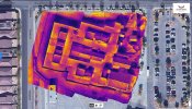
Mavic 2 Enterprise Advanced
The M2EA will process in Drone Deploy and the output will be radiometric. The image set I ran though had inaccurate temperatures. The detail of the ortho was not that great. I am sure Drone Deploy being the innovator that it is will address and fix this. I think this is more of a camera calibration issue, especially since the M2EA's images are distorted.
Mavic 2 Enterprise Advanced low overlap images. This ortho is radiometric

www.dronedeploy.com
Flat/Low Slope Roof Moisture Survey

www.dronedeploy.com
Pix4D
Pix4D needs high overlap to process correctly. At this time you will have to process as an RGB ortho.
BUT, there is software now available to convert the DJI proprietary RJPEG to radiometric TIFF and you can then use this in Pix4D to create a true radiometric ortho. Here is a link to a thread on the sister site Mavic Pilots where a member shares his Radiometric output in Pix4D. This conversion software is pricey though.
I finally had time to go out and obtain the images to make a thermal map with the Enterprise Advanced. Pix4D wanted 90 front and 90 side overlap per the directions and I found this to make the aircraft fly at only 2-3 mph. I do think that DJI Pilot does not have the correct information about...

mavicpilots.com
View attachment 3302
Pix4D Output in ArcMap
View attachment 3303
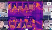
Reality Capture
In my testing this was a big welcome surprise. Low overlap images that would not process in Pix4D, processed fine in Reality Capture. This is non-radiometric. The pay when you export pricing works great in that you only pay to download the outputs when happy with the results. On such low resolution images the pricing is pennies for small areas.
Reality Capture high Overlap Mavic 2 Enterprise Advanced
View attachment 3304
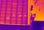
Reality Capture images that did not have enough overlap to process in Pix4D of a solar panel array. With 90/90 overlap I think the results would of been better.
View attachment 3305
View attachment 3306


")


