Most people are aware that flying over solar panels with an infrared camera is a quick and easy way to inspect them. But you also have to consider the depth of which you want to take your inspection. If you are inspecting the panels only, you would still need a regular or (RGB) camera. The anomaly you detect with your Thermal Camera could be mud or even bird droppings. Solar Installations are more than just panels. There is a lot of wiring and connections as well as a sizable junction box. All of these areas should be checked if you are doing a full inspection. Once you are inspecting the backside, a handheld thermal camera would be needed, as most panels would be tilted up and difficult to access with your bird. Just some things to keep in mind if you start thinking Solar.


You are using an out of date browser. It may not display this or other websites correctly.
You should upgrade or use an alternative browser.
You should upgrade or use an alternative browser.
Considerations for Solar Inspection
- Thread starter Kelly
- Start date

Outta Control
Well-Known Member
- Joined
- Jan 12, 2018
- Messages
- 587
- Reaction score
- 333
- Age
- 59
- Location
- San Jose, CA
- Website
- www.hoveranalytics.com
I do not think near-infrared would be enough.
From what Kelly stated Solar inspection are not that difficult, if you execute your technique and data gathering correctly. I agree that the use of RGB is a bonus but I primarily use it to quickly scan the panel post IR. Part of data acquisition is identifying the type of panels as they each have a different data from each other.
I do, disagree with Kelly in that, "...a handheld thermal camera would be needed, as most panels would be tilted up and difficult to access with your bird..."
It is all about the right angle, understanding the type of lens and the parallax it creates, and using the basic concept from FLIR such as FoRD. This is what I suspected from all the solar panels I have inspected in the past 2 years and was confirmed during my certification course in sUAS Thermography.
Last edited:
Outta Control
Well-Known Member
- Joined
- Jan 12, 2018
- Messages
- 587
- Reaction score
- 333
- Age
- 59
- Location
- San Jose, CA
- Website
- www.hoveranalytics.com
@ArrUnTuS
Near Infrared can be used in Solar Panel inspection. Solar Cell Inspection Applications | FLIR Systems
Near Infrared can be used in Solar Panel inspection. Solar Cell Inspection Applications | FLIR Systems
Outta Control
Well-Known Member
- Joined
- Jan 12, 2018
- Messages
- 587
- Reaction score
- 333
- Age
- 59
- Location
- San Jose, CA
- Website
- www.hoveranalytics.com
@Kelly
Though it can be done, what you have presented is basically a theoretical NDT of a solar cell that has to be illuminated or (reversed operation) to a SWIR camera.
In practical terms, that is not a valid method for any aerial work as aerial sUAS work looks at a gross FoV or even at a mFoV. Here are the problems on the video.
#1 - The video tested a small solar sample just shy larger than a credit card and though it did isolated an anomaly, it took over 250 images just to render the difference.
#2 - Your bigger problem is reflection. If the panel has to be illuminated there is no way you would conduct these test during day light hours.
#3 - Lastly unless you have time and money to experiment on the viability of solar panel inspection from a $80K FLIR Optical Gas SWIR camera, that can be mounted on a sUAS, it is just a waste of time.
Maybe some day FLIR may offer a robust SWIR for a sUAS use but as of today there are just too many factor than can affect the accuracy of the data.
@Outta Control
My intent was to show the depth of what could be done. In my original post I tried to show some of the considerations to ponder if you were interested in Solar Panel inspection. You disagreed with some of my observations as to the use of handheld devices, which is fine. Different strokes. In your rebuff, you also say you use RGB as a quick scan post IR. Why would you fly twice if you could do it all at once. Being that solar panel inspection is qualitative and not quantitative. I think it depends a lot with what you are comfortable with. It doesn't matter if I do it the same way as you do it as long as we both arrive at the same answer.
My intent was to show the depth of what could be done. In my original post I tried to show some of the considerations to ponder if you were interested in Solar Panel inspection. You disagreed with some of my observations as to the use of handheld devices, which is fine. Different strokes. In your rebuff, you also say you use RGB as a quick scan post IR. Why would you fly twice if you could do it all at once. Being that solar panel inspection is qualitative and not quantitative. I think it depends a lot with what you are comfortable with. It doesn't matter if I do it the same way as you do it as long as we both arrive at the same answer.
ArrUnTuS
Well-Known Member
- Joined
- Jan 5, 2018
- Messages
- 360
- Reaction score
- 146
@ArrUnTuS
I think I may be starting to understand your confusion. When I speak of RGB and Thermal, I am speaking of two separate cameras contained in the same enclosure. The Parrot is combining the RGB and the Near Infrared in one camera. The Electromagnetic Spectrum is made up of various Wavelengths. Infrared wavelengths fall between Visible Light wavelengths and Microwave wavelengths. If you were to break up the Infrared wavelengths into three sections you would have Near Infrared, Infrared, and Far Infrared. Near Infrared would be the closest to Visible light, and Far Infrared would be the closest to Microwave. So what you are using with the Parrot would not be the full Infrared band. I hope this makes sense. Sometimes I know what I want to say, but not sure I say it so some one else can understand it.
I think I may be starting to understand your confusion. When I speak of RGB and Thermal, I am speaking of two separate cameras contained in the same enclosure. The Parrot is combining the RGB and the Near Infrared in one camera. The Electromagnetic Spectrum is made up of various Wavelengths. Infrared wavelengths fall between Visible Light wavelengths and Microwave wavelengths. If you were to break up the Infrared wavelengths into three sections you would have Near Infrared, Infrared, and Far Infrared. Near Infrared would be the closest to Visible light, and Far Infrared would be the closest to Microwave. So what you are using with the Parrot would not be the full Infrared band. I hope this makes sense. Sometimes I know what I want to say, but not sure I say it so some one else can understand it.
Outta Control
Well-Known Member
- Joined
- Jan 12, 2018
- Messages
- 587
- Reaction score
- 333
- Age
- 59
- Location
- San Jose, CA
- Website
- www.hoveranalytics.com
@ArrUnTuS I know what you are talking about and your question is valid.

Here is a the chart of the Electromagnetic Spectrum.

@Kelley
A near-IR camera such as the Parrot, Sentera, MAPiR,and others are all Multi-Spectral camera that are designed with different sensor filters.
There are a very few NIR camera that posses an RGB on it.
Sentera

Here is a the chart of the Electromagnetic Spectrum.
@Kelley
A near-IR camera such as the Parrot, Sentera, MAPiR,and others are all Multi-Spectral camera that are designed with different sensor filters.
There are a very few NIR camera that posses an RGB on it.
Sentera
Last edited:
Outta Control
Well-Known Member
- Joined
- Jan 12, 2018
- Messages
- 587
- Reaction score
- 333
- Age
- 59
- Location
- San Jose, CA
- Website
- www.hoveranalytics.com
Agreed but you need to be more practical in sharing and educating folks that are uninformed.@Outta Control
My intent was to show the depth of what could be done. In my original post I tried to show some of the considerations to ponder if you were interested in Solar Panel inspection. You disagreed with some of my observations as to the use of handheld devices, which is fine. Different strokes.
I fly the RGB first to look at it form a gross view perspective. Then execute the IR Mission. For your edification I have another aircraft that has both 18x zoom RGB and a IR thermal. You think that suits your mission?... In your rebuff, you also say you use RGB as a quick scan post IR. Why would you fly twice if you could do it all at once...
If I may ask, when was the last time your client asked you for a spot meter. If so how can you be accurate that you reading are correct....Being that solar panel inspection is qualitative and not quantitative. I think it depends a lot with what you are comfortable with.
It depends. I would possibly agree with you on a qualitative analysis but I surely would not on a quantitative....It doesn't matter if I do it the same way as you do it as long as we both arrive at the same answer.
Please let me be clear.
I have nothing against anyone that dive into thermal to be knowledgeable, because I once was in the same position and I knew my limit, but when someone continues to go down that rabbit hole, then they are on their own.
In an effort to help others, I posted here. Every reply from you has been argumentative and somehow dismissive of my observations. I was not looking for a pissing contest here. I'm sure that your knowledge is far superior to mine and that your equipment would surely make mine look paltry.
Outta Control
Well-Known Member
- Joined
- Jan 12, 2018
- Messages
- 587
- Reaction score
- 333
- Age
- 59
- Location
- San Jose, CA
- Website
- www.hoveranalytics.com
In an effort to help others, I posted here. Every reply from you has been argumentative and somehow dismissive of my observations. I was not looking for a pissing contest here. I'm sure that your knowledge is far superior to mine and that your equipment would surely make mine look paltry.
If you can believe I am not argumentative. I just don't like inaccurate information. It is okay for all of us to learn and that includes myself.
I know what I know and do not deviate or elevate it.
If I drift off my knowledge base then I will note it.
I am not calling you out but some of the info you did express becomes a little questionable.
ArrUnTuS
Well-Known Member
- Joined
- Jan 5, 2018
- Messages
- 360
- Reaction score
- 146
Forgive me for insisting, but ignorance is what it has 
For example, to inspect solar panels it has to be an infrared camera with the whole spectrum? Wouldn't the Sequioia be valid? I asked because I find it interesting to have both IR and RGB.
Apart from Sequoia, I have access to a Flir vue pro R and the idea I already had is to adapt a small RGB camera to get the two images, synchronize them and make it easier to visually understand the data being viewed.
Would both options be valid? Just one? Advantages or disadvantages?
Thanks to both of you")
For example, to inspect solar panels it has to be an infrared camera with the whole spectrum? Wouldn't the Sequioia be valid? I asked because I find it interesting to have both IR and RGB.
Apart from Sequoia, I have access to a Flir vue pro R and the idea I already had is to adapt a small RGB camera to get the two images, synchronize them and make it easier to visually understand the data being viewed.
Would both options be valid? Just one? Advantages or disadvantages?
Thanks to both of you
Outta Control
Well-Known Member
- Joined
- Jan 12, 2018
- Messages
- 587
- Reaction score
- 333
- Age
- 59
- Location
- San Jose, CA
- Website
- www.hoveranalytics.com
So there are two different subjects you are talking about. One is NIR (near-infrared) and true Infrared.
I hope, this diagram will clear this discussion.
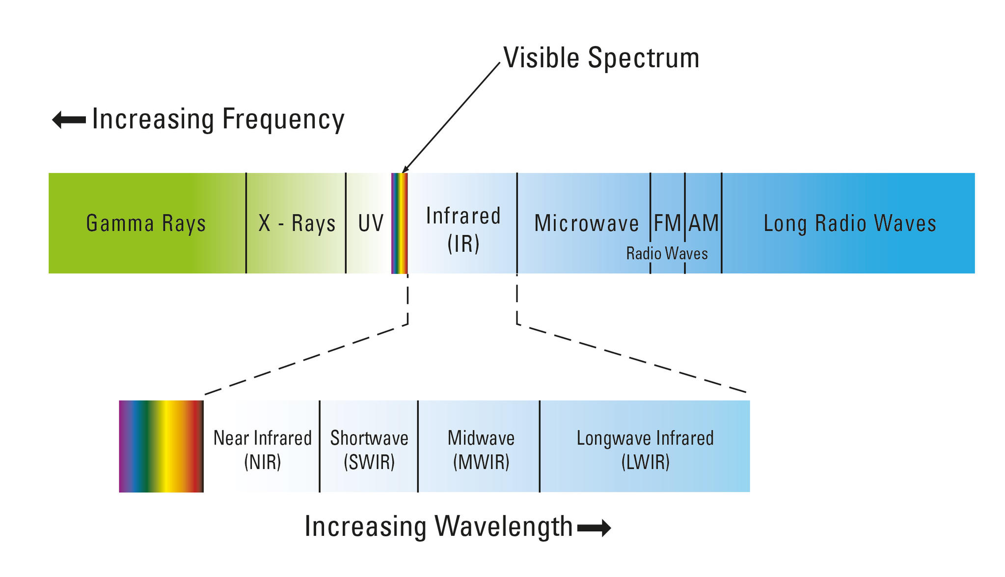
As you can on this chart, the video that Kelly provided only covered a theoretical concept using a SWIR, which already has a longer wavelenght than a NIR such as a Sentera or Parrot, thus as I expressed that a modded DJI X3 to read NIR has major limitations. So don't buy into these types of upgrade because once you do the mod you can never return back to a RGB camera.
Now for the Vue, Duo, and others, these are LWIR (Long-Wave Infrared) cameras, so there is no way these camera can or will do NIR.
Anyone tell you other wise is highly misinformed.
I hope, this diagram will clear this discussion.
As you can on this chart, the video that Kelly provided only covered a theoretical concept using a SWIR, which already has a longer wavelenght than a NIR such as a Sentera or Parrot, thus as I expressed that a modded DJI X3 to read NIR has major limitations. So don't buy into these types of upgrade because once you do the mod you can never return back to a RGB camera.
Now for the Vue, Duo, and others, these are LWIR (Long-Wave Infrared) cameras, so there is no way these camera can or will do NIR.
Anyone tell you other wise is highly misinformed.
LUIS MARTINEZ
Well-Known Member
- Joined
- Dec 24, 2017
- Messages
- 1,218
- Reaction score
- 1,048
- Age
- 73
- Location
- CASA GRANDE, AZ
- Website
- www.martinezaerial.com
In an effort to help others, I posted here. Every reply from you has been argumentative and somehow dismissive of my observations. I was not looking for a pissing contest here. I'm sure that your knowledge is far superior to mine and that your equipment would surely make mine look paltry.
Kelly, try to take a Level 1 Thermography class, when you can (they are expensive) . They are taught by experienced Level 3 Thermographers and after class you'll have access to expert advice. Level 3s are qualified in the IR industry, not just UAS. Once you complete the course you'll know how much you didn't know about IR and how to plot your future learning path. It's a vast field.
Ok gang... let's ALL take a big breath here. Like so many other sUAS topics this one is getting a bit "passionate" and we need to all agree to disagree.
@LUIS MARTINEZ
Hopefully we can end all of this here. I was going to leave it all with my last post, however, let me defend myself. Level 1 Thermographer, Level 1 Infrared Building Surveyor, Infrared Energy Loss Surveyor, Infrared Moisture Surveyor, Aerial Thermography Certificate from UAV Coach / AeroVista Innovations as taught by Brendan Stewart. I have a certification for each one of these levels. None of this means I am a Thermal God. I am a tired old man who just tried to help.
Hopefully we can end all of this here. I was going to leave it all with my last post, however, let me defend myself. Level 1 Thermographer, Level 1 Infrared Building Surveyor, Infrared Energy Loss Surveyor, Infrared Moisture Surveyor, Aerial Thermography Certificate from UAV Coach / AeroVista Innovations as taught by Brendan Stewart. I have a certification for each one of these levels. None of this means I am a Thermal God. I am a tired old man who just tried to help.
LUIS MARTINEZ
Well-Known Member
- Joined
- Dec 24, 2017
- Messages
- 1,218
- Reaction score
- 1,048
- Age
- 73
- Location
- CASA GRANDE, AZ
- Website
- www.martinezaerial.com
I was sticking up for you, brother...@LUIS MARTINEZ
Hopefully we can end all of this here. I was going to leave it all with my last post, however, let me defend myself. Level 1 Thermographer, Level 1 Infrared Building Surveyor, Infrared Energy Loss Surveyor, Infrared Moisture Surveyor, Aerial Thermography Certificate from UAV Coach / AeroVista Innovations as taught by Brendan Stewart. I have a certification for each one of these levels. None of this means I am a Thermal God. I am a tired old man who just tried to help.


New Posts
-

-

-
-
-
 Sharing My Music and Sound Effects - Over 2000 Tracks
- Latest: Eric Matyas