Welcome, Commercial Drone Pilots!
Join our growing community today!
Sign up

DJI M3M Focus Issues

Raptor

Member
Joined
Jan 22, 2018
Messages
22
Reaction score
5
Location
Kingwood, TX
Website
www.raptoraerialservices.com
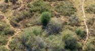
Using the DJI M3M drone, I have had a tough time getting real-time focus feedback to the RC Pro screen. I have had to play with this a bit to get focus to work. Using a combination of Automatic focus then switching to MF and set camera to “mountain” or infinity. Where is the MF Assist option? I cannot find it anywhere. I have always found this feature useful.
 
First off, what are you using it for???
1. If you are doing mapping the software is setting the focus
2. The M3M like most Enterprise level drones have very limited manual camera settings, if you thought you would be able to tinker with camera setting you bought the wrong drone
 
First off, what are you using it for???
1. If you are doing mapping the software is setting the focus
2. The M3M like most Enterprise level drones have very limited manual camera settings, if you thought you would be able to tinker with camera setting you bought the wrong drone
We are doing a research project using drone imagery to identify and study plant invasive species over a 2-3 year period.
 
We are doing a research project using drone imagery to identify and study plant invasive species over a 2-3 year period.
Nice project, but it doesn't explain the issue or desired result of what want to achieve. You spoke of wanting to be able to manually adjust the focus or be able to get better results? There are few if any better drone solutions out there than the M3M currently unless you are looking to move up to a LiDar system, also it may be a software issue, as in its ability to reproduce a higher resolution for analysis.
 
Nice project, but it doesn't explain the issue or desired result of what want to achieve. You spoke of wanting to be able to manually adjust the focus or be able to get better results? There are few if any better drone solutions out there than the M3M currently unless you are looking to move up to a LiDar system, also it may be a software issue, as in its ability to reproduce a higher resolution for analysis.
The primary deliverable is a set of RAW images. The University doing the research plans to apply AI to identify the various invasive plant species and changes over time. I have working with Advexure technical support staff to tweak the survey specs. I flew a 110 acre RGB test survey at 155 ft, 70/80% overlap, 11 mph, shutter speed 1/2000, and AFC (vs manual focus). The JPG images look good but the RAW images still a little “fuzzy”. Below are several screen captures.
 

Attachments

  • image001.png
    image001.png
    2.1 MB · Views: 5
  • image003.png
    image003.png
    2.3 MB · Views: 5
  • image002.png
    image002.png
    2 MB · Views: 5
  • image004.png
    image004.png
    2 MB · Views: 4
The primary deliverable is a set of RAW images. The University doing the research plans to apply AI to identify the various invasive plant species and changes over time. I have working with Advexure technical support staff to tweak the survey specs. I flew a 110 acre RGB test survey at 155 ft, 70/80% overlap, 11 mph, shutter speed 1/2000, and AFC (vs manual focus). The JPG images look good but the RAW images still a little “fuzzy”.
I would suggest slowing down the speed of the drone to around 5-7 Mph. The lower to the ground any camera is subject to motion blur, there is no exact chart to follow but terrain type and speed are the biggest factor to consider. With mapping type flights you are taking several induvial shots stitched together, so each shot is like taking one single picture by itself. The slower speed will allow the camera to gain the needed full focus from edge to edge.
 
I bought this drone primarily for the Mechanical Shutter. I was told, prior to buying the M3M, that I could successfully capture RAW images at about 10 mph. My Autel Evo 2 Pro 6K drones required 4.5 mph due to electronic shutter. The terrain is very flat, less than 2ft difference elevation over 110 acres. I am flying RTK and using terrain following. It was also recommend to fly with shutter speed between 1/500-1/2000, so I chose 1/2000.
 
I bought this drone primarily for the Mechanical Shutter. I was told, prior to buying the M3M, that I could successfully capture RAW images at about 10 mph. My Autel Evo 2 Pro 6K drones required 4.5 mph due to electronic shutter. The terrain is very flat, less than 2ft difference elevation over 110 acres. I am flying RTK and using terrain following. It was also recommend to fly with shutter speed between 1/500-1/2000, so I chose 1/2000.
That information is correct, but apparently that is for JPeg shots not RAW. Raw files are much larger with much more information (dynamic range/detail), to get the most out of the 4/3 sensor it needs to fly slower. Give it a try and see the results.
 
Question about real-time follow. Per your recommendation, I set the Terrain Following Altitude to 155 ft or 1.27 cm/pixel (0.5 in/pixel) Ortho GSD. I have done this for all drone surveys since my initial test surveys. See screen capture as an example. Based on the flight logs, the drone never actually flies at 155 ft AGL, even at the take-off point. The drone actually flew to 164 ft AGL then flew at 170-180 ft AGL. The areas I am flying are extremely flat. Ranging from 165 to 169 ft AMSL. So 4-5 max difference from low to high elevation. There are bushes and shrubs throughout the property. An occasional tree. Why doesn't the drone generally fly from 155-160 ft AGL vs 164-180ft AGL? Does the drone sensor pickup every bush, shrub, and tree? I have seen this difference consistently in multiple areas.
 

Attachments

  • Screenshot_20231220-115413.png
    Screenshot_20231220-115413.png
    2.1 MB · Views: 1
  • 2024-01-10_07-25-22.jpg
    2024-01-10_07-25-22.jpg
    1.2 MB · Views: 1
  • 2024-01-10_08-34-10.jpg
    2024-01-10_08-34-10.jpg
    338 KB · Views: 1
Last edited:
Question about real-time follow. Per your recommendation, I set the Terrain Following Altitude to 155 ft or 1.27 cm/pixel (0.5 in/pixel) Ortho GSD. I have done this for all drone surveys since my initial test surveys. See screen capture as an example. Based on the flight logs, the drone never actually flies at 155 ft AGL, even at the take-off point. The drone actually flew to 164 ft AGL then flew at 170-180 ft AGL. The areas I am flying are extremely flat. Ranging from 165 to 169 ft AMSL. So 4-5 max difference from low to high elevation. There are bushes and shrubs throughout the property. Why doesn't the drone from 155-160 ft AGL vs 164-180ft AGL? I have seen this difference consistently in multiple areas.
I don't know the exact science behind terrain follow, but the use of the drones sensors is key in what it perceives as the ground distant from the drone. I have flown a few sites using terrain awareness and have seen fluctuations ranging from a few feet to over 100 feet. The main goal is to have the drone to be able to maintain a certain altitude for a more uniform/accurate ortho mosaic picture when all the shots are stitched together.
 
I am using a DJI M3M drone. For several of my research oriented mapping projects I need to capture both JPG and RAW (DNG) images. Related to the RAW (DNG) images, what are recommended settings? Focus is critical.

Camera Settings:
  1. Shutter (S) Priority?
  2. Focus – AFC or Manual. If Manual, what steps do you using take to properly set MF?
  3. Shutter Speed – 1/1000 or greater
  4. ISO – 100 to 200?
Survey Specs:
  1. Overlap: 80/80?
  2. Reat-Time Terrain Follow @ 150’ AGL? Or Relative to Takeoff Point @ 150’ ALT
  3. GSD: ~1.27 cm/pixel ( ~0.5 inches/pixel)?
  4. Drone Speed: <10 mph?
what were the results of you flying slower or stopping to take each picture?????
 
what were the results of you flying slower or stopping to take each picture?????
See attached screen captures of a couple of raw images (zoomed in). All shot a 9 mph, 80/70 overlap, 0.5 in/px GSD, and real-time terrain following. It looks like the stationary images are slightly better but only marginally, if at all. I think AFC is better than MF. Thoughts?
 

Attachments

  • Stationary-AFC.jpg
    Stationary-AFC.jpg
    465.6 KB · Views: 6
  • Moving-AFC.jpg
    Moving-AFC.jpg
    465.6 KB · Views: 6
  • Moving-MF.jpg
    Moving-MF.jpg
    393.5 KB · Views: 6
  • Stationary-MF.jpg
    Stationary-MF.jpg
    393.5 KB · Views: 6
Last edited:
See attached screen captures. All shot a 9 mph. It looks like the stationary images are slightly better but only marginally, if at all. I think AFC is better than MF. Thoughts?
with shutter priority, it should default to AFC/AF mode.
 
I am still struggling with focus issues with the M3M. This time with normal RGB JPG photos. I have tried both AFC and MF. The way I do Manual Focus is the following. Set the camera to AFC. Fly to the altitude of the survey (150 or 200 ft) and fly over an area with clear view of the ground. I click on the camera cursor on the RC screen then set to MF and click on the mountain (to infinity). Any thoughts as to how to get repeatable “in focus” imagery?
 
I am still struggling with focus issues with the M3M. This time with normal RGB JPG photos. I have tried both AFC and MF. The way I do Manual Focus is the following. Set the camera to AFC. Fly to the altitude of the survey (150 or 200 ft) and fly over an area with clear view of the ground. I click on the camera cursor on the RC screen then set to MF and click on the mountain (to infinity). Any thoughts as to how to get repeatable “in focus” imagery?
You may need to send that in for DJI to check with focus issues, looking back at the photos you taken doesn't add up. Here are a few with my M3M at 400 ft, flying speed of 19mph taken last week on a project.

DJI_0004.JPGDJI_0005.JPGDJI_0094.JPGDJI_0096.JPG
 

New Posts

Members online

No members online now.

Forum statistics

Threads
4,294
Messages
37,666
Members
5,992
Latest member
GerardH143