- Joined
- Feb 3, 2018
- Messages
- 45
- Reaction score
- 9
- Age
- 69
- Location
- Weston, Florida
- Website
- www.westonaerialphoto.com


Post the actual image file and I'll find out what I can for you (original file .. the jpg is fine if you have it)I am looking at the metadata but the altitude it indicates seems too low...how do I know at what height the pic was taken?
Post the actual image file and I'll find out what I can for you (original file .. the jpg is fine if you have it)
There are two altitudes buried in the metadata for that image.. . .

It's in the image metadata.However, when I hunt through the dji mavic 2 pro flight logs (when flying with the dji go app) no where can I find gps altitude logged.
Absolute altitude is DJI's "rough" approximation of altitude above sea level.
But because of the way they calculate it, this is always wrong, sometimes a couple of hundred feet out and the number is useless.
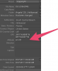
All you said makes a lot of sense. Thank you very much. By the way, which app are you using to get the full metadata details? In Lightroom I don't see all the info you see.There are two altitudes buried in the metadata for that image.
Absolute Altitude: 19.02 metres
Relative Altitude: 76.40 metres
Absolute altitude is DJI's "rough" approximation of altitude above sea level.
But because of the way they calculate it, this is always wrong, sometimes a couple of hundred feet out and the number is useless.
Relative Altitude is the height above launch point as shown on your flying screen.
This should be accurate +/- a couple of metres.
So ... you shot that pic at about 76 metres or 249 feet.
It's in the image metadata.
You just have to know where to look.
That was Picture Information Extractor (and that was only part of the information)All you said makes a lot of sense. Thank you very much. By the way, which app are you using to get the full metadata details? In Lightroom I don't see all the info you see.


We use essential cookies to make this site work, and optional cookies to enhance your experience.