Welcome, Commercial Drone Pilots!
Join our growing community today!
Sign up

Military Training Routes

David Walton

New Member
Joined
Jan 15, 2018
Messages
4
Reaction score
1
Age
67
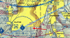
I live under a Visual Route(VR), and routinely have fighter aircraft screaming through the air over 300mph at 250-500 ft. I contacted the FAA in an effort to find out when this route has someone in it. The best they could do was a website sua.faa.gov. You can find the correct sectional and thus locate either an IR(IFR Route) or a VR . Look around and find filter and you can find out the hours(in my case, continuous) and the altitude for a particular segment. It says 1000 to 1500 AGL, but they are much lower. In short, the appears to be no way of finding out when aircraft will be in one of these routes(except for IR). Use CAUTION because these aircraft have 5 miles or more from the centerline, and are moving fast. I do not want to find out if an Inspire 1 will bring down a fighter.
 
This is true. If, the sectional chart has a four digit VR, it's at or below 1500' AGL. If it has three digits it will be at or above 1500' AGL. There is no way to know when they are coming as it is completely up to the pilot. I have one near me as well, and I see fighter jets scream by at only a few hundred feet AGL. Fun to watch, but a little crazy when you have a drone in the air.
 
UK

The whole of UK airspace is used for low flying exersizes - surface to 2000ft AGL. It's not possible to find out where or when in advance either. I frequently watch Hercules flying past at around 300 - 500 ft, but at least you can hear them coming.
 
Having your drone sucked into a fighter jet engine would make for a bad day for both you and the fighter pilot.
 
Have a IR route over my ranch. If you study military routes, you’ll see they all vary in altitude. I contacted the local FSDO and they looked it up and told me over my ranch they should not be lower than 500ft. I have learned the FSDO is your friend for UAS.
 
  • Like
Reactions: BigAl07
We have an reserve army blackhawk unit in our area, first of all they don't stay within VR routs, and fly at whatever altitude they seem to prefer. Fortunately I don't have any fast moving fighters to contend with. I just keep a watch for them and make sure I stay out of their way.
 
  • Like
Reactions: rvrrat14
I am exactly on the edge of a class D veil of an airport which is both civilian and military. A couple of miles to the north of me is a large gravel bank the the C 130's use for practicing cargo drops. The hercs come over my house at about 200'. I make it a practice that if they are up, I am down.
 
My memory method is 4 below. VR1234 = below 1500.
Question, how is a 2 digit MTR interpreted? I have one over my house that says V10-12 (not VR). The only thing Ive ever seen are helicopters, just recently.
Arrow is where I am in image.
 

Attachments

  • VR.png
    VR.png
    792.7 KB · Views: 7
Last edited:
I am exactly on the edge of a class D veil of an airport which is both civilian and military. A couple of miles to the north of me is a large gravel bank the the C 130's use for practicing cargo drops. The hercs come over my house at about 200'. I make it a practice that if they are up, I am down.
200' ????? That must shake your house pretty good!
 
I don’t see a MTR on the map.....I do see a Victor flight path.
 
Last edited:
Question, how is a 2 digit MTR interpreted? I have one over my house that says V10-12 (not VR). The only thing Ive ever seen are helicopters, just recently.
Arrow is where I am in image.
Any route with either Victor (V10 is a low altitude IFR route). J = a high altitude Jet route above FL180. In your case v10 and V12 are he same route for a while. Check your IFR low charts
 
I do flights almost weekly that take place in the Owens MOA, where they can fly down to 200’ and I can be up to 400’. It is my responsibility to let them know I’m there. I phone/ email at the ATC at least 24 hours ahead of my flight time and submit a DROTUM through 1800briefx.com. Doing this makes flying in MOA areas much less stressful. I have done my part to let them know I’m there, instead of guessing when they’ll be around. For security reasons they likely don’t make their training times public. It seems that since they know I’m there they often fly around the boundary I’ve set up, perhaps looking for some large UAV.

Nik


Well played! I operate within a MOA here in western NC and when we had a large scale SAR training event (at one time we had 20" UAS flying at the same time) I did the same thing. They denied my 400' DROTAM (outright said NO) and we finally were allowed 300'AGL and a HARD limit. Yes this was via DROTAM before anyone suggests I'm confusing Drotams and Airspace Authorizations etc.
 

New Posts

Members online

No members online now.

Forum statistics

Threads
4,294
Messages
37,666
Members
5,992
Latest member
GerardH143