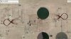
I've been adapting my curved flight lines to address long, narrow corridors (electric power transmission corridors). This example was flown using a fixed-wind drone flying at 31mph with a height of 400' AGL. The corridor is approximately a mile long with a width of about 2200'. The target area is very flat. The objective is to mitigate the systematic SfM doming (elevation) error. No flight line segment is parallel to any other segment and no flight line segment is linear. Therefore, no two images have the same orientation.


You are using an out of date browser. It may not display this or other websites correctly.
You should upgrade or use an alternative browser.
You should upgrade or use an alternative browser.
Owning a drone does not make you a surveyor or photogrammetrist.
- Thread starter BigAl07
- Start date
Weaponized
Well-Known Member
- Joined
- Jun 25, 2018
- Messages
- 90
- Reaction score
- 25
- Age
- 64
Not a whole lot different than a photographer or droner performing "inspections' with zero expertise in what they're inspecting. While they claim they're only "collecting images" for someone else, they're marketing their product as an inspection which creates the illusion in the public eye that they're an inspector.
LUIS MARTINEZ
Well-Known Member
- Joined
- Dec 24, 2017
- Messages
- 1,218
- Reaction score
- 1,048
- Age
- 73
- Location
- CASA GRANDE, AZ
- Website
- www.martinezaerial.com
Not a whole lot different than a photographer or droner performing "inspections' with zero expertise in what they're inspecting. While they claim they're only "collecting images" for someone else, they're marketing their product as an inspection which creates the illusion in the public eye that they're an inspector.
That's a rather narrow interpretation of the service we offer. I sell images taken from an elevated platform, that's all. If I'm asked to image a construction site, must I be a building contractor or an architect ? If I'm asked to image a cell tower must I be an electronics engineer? Of course not. The experts are only asking for images, not an expert opinion.
I agree with the basic premise of this thread; drone pilots must understand the limitations of their knowledge and equipment unless trained and licensed by their respective state as surveyors, which requires considerable time, knowledge and experience, and no, buying a Phantom RTK does not make you a surveyor.


Weaponized
Well-Known Member
- Joined
- Jun 25, 2018
- Messages
- 90
- Reaction score
- 25
- Age
- 64
I'm merely pointing out the parallel given the topic. Taking photos for any purpose doesn't exactly lend itself to a very wide interpretation of anything, except when used as art.That's a rather narrow interpretation of the service we offer. I sell images taken from an elevated platform, that's all. If I'm asked to image a construction site, must I be a building contractor or an architect ? If I'm asked to image a cell tower must I be an electronics engineer? Of course not. The experts are only asking for images, not an expert opinion.
I agree with the basic premise of this thread; drone pilots must understand the limitations of their knowledge and equipment unless trained and licensed by their respective state as surveyors, which requires considerable time, knowledge and experience, and no, buying a Phantom RTK does not make you a surveyor.
Not 2 days ago I read a post in a facebook group asking what one needed to do to inspect in a major metropolitan area with strict airspace rules. The guy was a photographer. Why didn't he ask what he needed to do to "fly", or take aerial photos?
I don't know. Maybe he just wants to inspect the air.
LUIS MARTINEZ
Well-Known Member
- Joined
- Dec 24, 2017
- Messages
- 1,218
- Reaction score
- 1,048
- Age
- 73
- Location
- CASA GRANDE, AZ
- Website
- www.martinezaerial.com
I'm merely pointing out the parallel given the topic. Taking photos for any purpose doesn't exactly lend itself to a very wide interpretation of anything, except when used as art.
Not 2 days ago I read a post in a facebook group asking what one needed to do to inspect in a major metropolitan area with strict airspace rules. The guy was a photographer. Why didn't he ask what he needed to do to "fly", or take aerial photos?
I don't know. Maybe he just wants to inspect the air.
"Taking photos for any purpose doesn't exactly lend itself to a very wide interpretation of anything, except when used as art."
Thanks for the clarification. Guess all those people paying me good money for what I do just wanted "art". Silly me.
Weaponized
Well-Known Member
- Joined
- Jun 25, 2018
- Messages
- 90
- Reaction score
- 25
- Age
- 64
I'm speaking simply of the act of taking photos in the context of a wide versus narrow interpretation, which is what you narrowed my observation to, don't read so much into it. I'm sure you're very good at what you do... Take all the pictures you like."Taking photos for any purpose doesn't exactly lend itself to a very wide interpretation of anything, except when used as art."
Thanks for the clarification. Guess all those people paying me good money for what I do just wanted "art". Silly me.
I'm simply drawing a parallel here…I take on average of 300 to 400 photos a day and have been doing so for 12 years now. I've never once called myself a photographer nor promote my services as anything other than what they are. That cannot be said for everyone in drone land and I know this because I've seen it with my own eyes.
My post was not an effort to blame you. I really don't know what you do.
All this discussion is good dialog; but in certain states (Florida, Mississippi, and North Carolina, for instance), there are good ole’ boy surveyors who don’t really embrace new technology they don’t want to learn; but do want to suppress any competition.
R Martin
Well-Known Member
I see the point of this article, but let's say all you do use the Maps Made Easy program and process with no ground control points, etc. How good is that data and isn't there a place for it even if it's not up to par with real surveying and photogrammetry?
Based upon my case, with no GCPs accuracy degrades from roughly 1/2" to 5ish meters with nothing but the onboard GPS providing location data. IMHO, that becomes just a pretty picture. You can use it for rough guesstimates on stockpile calculations and job tracking. As far as use as a map that will integrate with other widely used applications, the data is worthless.
Here is a good read for any/all of us but especially for those who are "doing it for hire" . . .
Owning a drone does not make you a surveyor or photogrammetrist.
Owning a drone does not make you a surveyor or photogrammetrist. A rant by the president of J.R. Canadian Mapping Ltd.
Seems that this has been the cry of photographers since the advent of low priced/high quality dSLR's - that along with news stations, magazines and others that put out on twitter (etc) that they would like images of "x" and will use the photo for a byline and get images they can use - it really doesn't matter if the image is the best - it's an image the producer can use.
I've read hours of posts in photography forums about the dilution of the profession of photography because willing amateurs submit for bylines or just to see their work published. Although there is some credence to this (IMHO) it also allows the hobby/profession to evolve as well as weeding out the pros that aren't able to read or stay ahead of the market trends and adapt.
Whether photography or drones (which is a stepchild of photography amongst others) or something else that technology makes available to the masses and the internet allows wide distribution, the motto, "evolve or die," comes to mind.

UAV_Mapper
Well-Known Member
- Joined
- Jan 9, 2018
- Messages
- 61
- Reaction score
- 41
- Age
- 48
With artistic photography, equipment is only as good as who's using it, and I'm certain that there have been plenty of amateur photographers that have won professional awards.Seems that this has been the cry of photographers since the advent of low priced/high quality dSLR's
But... the point of the original article was to distinguish between the amateur "mapper" and the professional surveyor. Most state survey boards are very clear about what is allowed to be produced and distributed, yet many amateur drone enthusiasts are making and selling "survey" maps to unknowing clients. In fact, a lot of "professionals" are offering services and don't even know that they're not allowed to be performing those services. This hurts the professional UAV mapping community that is trying to establish UAVs as an accurate and precise survey instrument. When unlicensed and untrained individuals get out of their scope of expertise, then it can have far reaching consequences and potentially lead to lawsuits.
We've discussed it before, but it's worth repeating that simple tasks like producing orthomosaics or volume estimates for stockpiles falls into Licensed Surveyor territory.
For example, take a look at Arizona's definition of "Land Surveying Practice":
(d) Measurement by angles, distances and elevations of natural or artificial features in the air, on the surface and immediate subsurface of the earth, within underground workings and on the surface or within bodies of water for the purpose of determining or establishing their location, size, shape, topography, grades, contours or water surface and depths, and the preparation and perpetuation of field note records and maps depicting these features.
Or California's:
(b) Determines the configuration or contour of the earth’s surface, or the position of fixed objects above, on, or below the surface of the earth by applying the principles of mathematics or photogrammetry.
Source is from ASPRS Compilation of State Survey Regulations (2015)
So, if you want to take a some pretty drone pictures and call yourself a professional photographer, go right ahead (just be sure to have your Part 107!), but if you want to start performing or advertising survey related tasks, be sure that you're legally allowed to do so. There are myriad ways to get incorrect survey data and you will lose when you have to explain on the stand why the PLS's data shows different values. Or, protect yourself, because you never know who's going to take your "for informational purposes only" map and design a subdivision from it.
Safe flying!
Phaedrus
Well-Known Member
All this discussion is good dialog; but in certain states (Florida, Mississippi, and North Carolina, for instance), there are good ole’ boy surveyors who don’t really embrace new technology they don’t want to learn; but do want to suppress any competition.
Add California to that list although I have heard talk that they are looking to lighten up on that a bit.
UAV_Mapper
Well-Known Member
- Joined
- Jan 9, 2018
- Messages
- 61
- Reaction score
- 41
- Age
- 48
I think that there are a lot of states where the belts are being tightened. Unfortunately, I don't know of any way for non-professionals to get recognized, other than to become licensed surveyors (or engineers in some states). I became certified as a UAV mapping scientist through ASPRS as a way to help promote their program, to add some professional credibility, and to hopefully show that there might be a happy medium between the PLS and the amateur mapper. Perhaps if there are enough certified drone mappers out there, we might eventually gain a voice and break down some of that "good 'ole boy" network.Add California to that list although I have heard talk that they are looking to lighten up on that a bit.
R Martin
Well-Known Member
I think that there are a lot of states where the belts are being tightened. Unfortunately, I don't know of any way for non-professionals to get recognized, other than to become licensed surveyors (or engineers in some states). I became certified as a UAV mapping scientist through ASPRS as a way to help promote their program, to add some professional credibility, and to hopefully show that there might be a happy medium between the PLS and the amateur mapper. Perhaps if there are enough certified drone mappers out there, we might eventually gain a voice and break down some of that "good 'ole boy" network.
If you are just starting off and do not mind paying your dues and putting in the time it requires RPLS is the way to go here. The average age a few years back was in the high 50's so there is a shortage and now is the time to step in. Drones are slowly making headway into the survey shops (at least here) but there is still a long road ahead before they are widely accepted and utilized to their capacity.
UAV_Mapper
Well-Known Member
- Joined
- Jan 9, 2018
- Messages
- 61
- Reaction score
- 41
- Age
- 48
We get a lot of younger pilots asking how they can get paid to fly drones. We tell them to get a degree in geomatics/surveying, GIS, or another similar field. Anyone can be trained to fly (especially when most mapping missions are automated), but it's what you do with the data afterwards that counts. I don't know why, but finding surveyors has been really hard for our company and others in the area. There's a lot of opportunity out there for those willing to get licensed at the moment.RPLS is the way to go here.
aerialimagery
Well-Known Member
- Joined
- Jan 10, 2018
- Messages
- 355
- Reaction score
- 91
We get a lot of younger pilots asking how they can get paid to fly drones. We tell them to get a degree in geomatics/surveying, GIS, or another similar field. Anyone can be trained to fly (especially when most mapping missions are automated), but it's what you do with the data afterwards that counts. I don't know why, but finding surveyors has been really hard for our company and others in the area. There's a lot of opportunity out there for those willing to get licensed at the moment.
Let's say you load the results to maps made easy and produce a map. Does this map have any value at all for planning purposes or making measurements?
R Martin
Well-Known Member
We get a lot of younger pilots asking how they can get paid to fly drones. We tell them to get a degree in geomatics/surveying, GIS, or another similar field. Anyone can be trained to fly (especially when most mapping missions are automated), but it's what you do with the data afterwards that counts. I don't know why, but finding surveyors has been really hard for our company and others in the area. There's a lot of opportunity out there for those willing to get licensed at the moment.
There are lucrative careers that are in desperate need of people willing to learn and be licensed. Unfortunately, it is not an instant road to a high-paying job which is what the younger generation is expecting. I can't honestly say I was any different when I was twenty but I wish that I had this opportunity then.
LUIS MARTINEZ
Well-Known Member
- Joined
- Dec 24, 2017
- Messages
- 1,218
- Reaction score
- 1,048
- Age
- 73
- Location
- CASA GRANDE, AZ
- Website
- www.martinezaerial.com
I think that there are a lot of states where the belts are being tightened. Unfortunately, I don't know of any way for non-professionals to get recognized, other than to become licensed surveyors (or engineers in some states). I became certified as a UAV mapping scientist through ASPRS as a way to help promote their program, to add some professional credibility, and to hopefully show that there might be a happy medium between the PLS and the amateur mapper. Perhaps if there are enough certified drone mappers out there, we might eventually gain a voice and break down some of that "good 'ole boy" network.
IMHO, best path for a youngster to a UAS career is give the military a few years up front and become trained to fly the big stuff, Reapers, Predators, et al. Build hours, get a Commercial pilot certificate and go to work with the big boys; Boeing, General Atomics or the govmn't. Ah to be young again!
UAV_Mapper
Well-Known Member
- Joined
- Jan 9, 2018
- Messages
- 61
- Reaction score
- 41
- Age
- 48
The short answer: Yes. Having even a single picture holds some amount of value and I'd rather have something than nothing. And volume estimates tend to be fairly good, even with only the on-board GPS.Does this map have any value at all for planning purposes or making measurements?
The long answer: Probably not, but it really depends on the data going into MME. The recreational grade GPS unit on your Phantom is, for surveying purposes, not very good in the horizontal and really bad in the vertical. If you're uploading precise photo locations from an RTK/PPK enabled drone, then your precision gets much better. There's also some inherent stretching and warping of uncontrolled maps, simply due to the software trying to reconstruct a 3D model with a convex lens. If you're able to add Ground Control Points, then your accuracy and precision have greatly improved and now you have some actual "real world" points to tie the model to. We go another step and always include independent check shots that are separate from the model creation step.
So, yes, you can get some value out of an orthomosaic that you create through DD, MME, PixCloud, etc., but it's generally not acceptable for any detailed planning, engineering, or legal boundary work, especially if you're only using the on-board GPS.
R.Perry
Well-Known Member
IMHO, best path for a youngster to a UAS career is give the military a few years up front and become trained to fly the big stuff, Reapers, Predators, et al. Build hours, get a Commercial pilot certificate and go to work with the big boys; Boeing, General Atomics or the govmn't. Ah to be young again!
That is very good advice, then you can sit for hours on end with nothing to do because AUTO is doing all the flying.
LUIS MARTINEZ
Well-Known Member
- Joined
- Dec 24, 2017
- Messages
- 1,218
- Reaction score
- 1,048
- Age
- 73
- Location
- CASA GRANDE, AZ
- Website
- www.martinezaerial.com
While well paid.That is very good advice, then you can sit for hours on end with nothing to do because AUTO is doing all the flying.
")


New Posts
-
 Sharing My Music and Sound Effects - Over 2000 Tracks
- Latest: Eric Matyas
-
-

-
