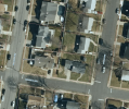
Hey all; I've got a guy who bought a lot in a city up in NorCal that burned to the ground (the whole city!) a couple years ago.
He contacted me asking if I could use my drone "for survey pictures". Of course I told him I'm not a licensed surveyer, so I can't offer a survey; but I can take photos and video.
As is fairly normal (in my experience, anyway), he wasn't quite sure exactly what he really needed. After talking to him, I looked up property lines in that neighborhood, and sure enough...there are no property lines around his new property.
From that info, I'm guessing that what he's *actually* trying to do is establish the boundaries for that plot.
So, if that's the case, my question for you guys is: What types of photos / videos should I take, that will be useful when he can hands them off to a surveyer (or whoever would officially re-establish those boundaries)?
It's just a small-ish, maybe .4 acre lot, in a full neighborhood (where there are no houses left standing due to the fire).
So...-90 gimbal tilt mapping pattern with lots of overlap? Perimeter photos with a POI in the middle-ish of the property? Something else entirely? Should I put some type of marker(s) down (like a blank CD) for reference for any reason?
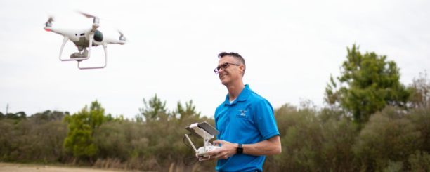
I'm probably going to fly in 2 days. And I'll either use Litchi or the Go4 app with my Mavic Pro.
I'd appreciate your insight...especially if you create property boundaries from drone photos!")
He contacted me asking if I could use my drone "for survey pictures". Of course I told him I'm not a licensed surveyer, so I can't offer a survey; but I can take photos and video.
As is fairly normal (in my experience, anyway), he wasn't quite sure exactly what he really needed. After talking to him, I looked up property lines in that neighborhood, and sure enough...there are no property lines around his new property.
From that info, I'm guessing that what he's *actually* trying to do is establish the boundaries for that plot.
So, if that's the case, my question for you guys is: What types of photos / videos should I take, that will be useful when he can hands them off to a surveyer (or whoever would officially re-establish those boundaries)?
It's just a small-ish, maybe .4 acre lot, in a full neighborhood (where there are no houses left standing due to the fire).
So...-90 gimbal tilt mapping pattern with lots of overlap? Perimeter photos with a POI in the middle-ish of the property? Something else entirely? Should I put some type of marker(s) down (like a blank CD) for reference for any reason?
I'm probably going to fly in 2 days. And I'll either use Litchi or the Go4 app with my Mavic Pro.
I'd appreciate your insight...especially if you create property boundaries from drone photos!