- Joined
- Jul 23, 2018
- Messages
- 3
- Reaction score
- 0
- Age
- 50
Hey everyone!
Newbie question ... first TFR ...
I have a flight request for a property located beneath a security TFR.
According to the TFR the restricted space is 4,100 to 18,000 MSL. I'll be flying under 200 ft AGL / 270 ft MSL.
My understanding is that I am okay to fly under the TFR without any concerns or issues. Can someone confirm?
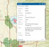
NOTAM Number : FDC 8/0269 Download shapefiles
Issue Date : August 02, 2018 at 2159 UTC
Location : Beale AFB, California near MARYSVILLE VOR/DME (MYV)
Beginning Date and Time : August 05, 2018 at 2200 UTC
Ending Date and Time : August 12, 2018 at 2159 UTC
Reason for NOTAM : Temporary flight restrictions for Special Security Reasons
Type : Security
Replaced NOTAM(s) : N/A
Jump To: Affected Areas
Operating Restrictions and Requirements
Other Information
Affected Area(s) Top
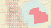
Airspace Definition:
Center: On the MARYSVILLE VOR/DME (MYV) 055 degree radial at 6.7 nautical miles. (Latitude: 39º08'03"N, Longitude: 121º26'15"W)
Radius: 10 nautical miles
Altitude: From and including 4100 feet MSL up to and including 18000 feet MSL
Effective Date(s):
From August 05, 2018 at 2200 UTC (August 05, 2018 at 1500 PDT)
To August 12, 2018 at 2159 UTC (August 12, 2018 at 1459 PDT)
Newbie question ... first TFR ...
I have a flight request for a property located beneath a security TFR.
According to the TFR the restricted space is 4,100 to 18,000 MSL. I'll be flying under 200 ft AGL / 270 ft MSL.
My understanding is that I am okay to fly under the TFR without any concerns or issues. Can someone confirm?
NOTAM Number : FDC 8/0269 Download shapefiles
Issue Date : August 02, 2018 at 2159 UTC
Location : Beale AFB, California near MARYSVILLE VOR/DME (MYV)
Beginning Date and Time : August 05, 2018 at 2200 UTC
Ending Date and Time : August 12, 2018 at 2159 UTC
Reason for NOTAM : Temporary flight restrictions for Special Security Reasons
Type : Security
Replaced NOTAM(s) : N/A
Jump To: Affected Areas
Operating Restrictions and Requirements
Other Information
Affected Area(s) Top
Airspace Definition:
Center: On the MARYSVILLE VOR/DME (MYV) 055 degree radial at 6.7 nautical miles. (Latitude: 39º08'03"N, Longitude: 121º26'15"W)
Radius: 10 nautical miles
Altitude: From and including 4100 feet MSL up to and including 18000 feet MSL
Effective Date(s):
From August 05, 2018 at 2200 UTC (August 05, 2018 at 1500 PDT)
To August 12, 2018 at 2159 UTC (August 12, 2018 at 1459 PDT)

")