Welcome, Commercial Drone Pilots!
Join our growing community today!
Sign up

What do you Charge for Drone Service

Hi Mike...Dan Grandmaison in Duluth, MN I do real estate photography of homes for the Realtors and hotels. My flat rate is $270 and I go up and around and down which takes about 12 minutes (stills only). Nobody has complained. Then I charge for the interiors and exteriors from ground level which is $295. So Drone and house total is pretty good for alot ot fun.

Thanks Dan for the thoughtful insight. DO you separate the traditional real-estate shoot from the out side drone pics? In other words, you charge $ 270 for the aerial and 295 for the traditional photography?
 
I'm a pro commercial photographer with 36 years experience, just breaking into the drone market. I intend to charge the same way as I always have, with a minimum of one hour @ $195.00, plus travel@ $95.00/hr or mileage if it's not over 45 minutes travel time. Then, a per finished image charge of $12.00-$25.00, depending on the client, the subject and the time needed in Photoshop. I'm assuming that any image delivered to a customer has to be adjusted, enhanced, straightened, color-corrected, and sized for the clients' needs. I NEVER deliver any image straight out of the camera, NOT EVER. You can build your own hourly rate, half and full-day rates, and special circumstance charges to finesse the invoice total so that it's fair to you and to your customer.
 
  • Like
Reactions: Marlene Lebel
We have heard a lot about Real Estate pricing. How about construction business. I'll go first. We don't have a set pricing for construction like we do for real estate. There are a number of reason why, but mainly construction typically requires mapping and additional expertise that is not required for the typical real estate shoot. We typically charge $ 195.00 per hour for single event jobs (think rock query) where we will measure the piles of dirt and rocks. We are currently working on an end-to-end solution that would provide weekly flights with complete reporting across all platforms, i.e., Desktop, Laptop, Tablet, and smart phone that will be used to send out alerts to the right people on the ground for tasks that need to be addressed. The Project Manager PM can look at the weekly mapping, then decide what needs to be done and send texts to the appropriate personnel for them to complete and once done send a text alert back to PM stating the task was completed. We have not priced this end-to-end solution yet, but depending on the size of the project will fall somewhere around $ 599.00 to 799.00 per week. The idea is to lock the construction company into a real, long term relationship across many projects at the same time.
 
It makes more sense to me to charge by the job instead of by the hour. Who wants to pay a photographer to drive his car? When I used to do a lot of aerial photography from airplanes my average job was $500 whether they were 10 or 500 miles away from me. But I would gang-up the jobs and do many at one time, often $10,000 in one day, so it made no sense to charge by the hour.

That market has dried up for me, but the same principle applies. I price my drone work from about $250 to $500 per job, and expenses and travel time are my problem so I strive to group as many together in one trip as possible.

Most drone jobs for me are less than one battery, or about 10 minutes of photography time, so again, the hourly charge doesn't make any sense to me. I would only consider that if I were working on one site day after day.
 
  • Like
Reactions: Marlene Lebel
We have heard a lot about Real Estate pricing. How about construction business. I'll go first. We don't have a set pricing for construction like we do for real estate. There are a number of reason why, but mainly construction typically requires mapping and additional expertise that is not required for the typical real estate shoot. We typically charge $ 195.00 per hour for single event jobs (think rock query) where we will measure the piles of dirt and rocks. We are currently working on an end-to-end solution that would provide weekly flights with complete reporting across all platforms, i.e., Desktop, Laptop, Tablet, and smart phone that will be used to send out alerts to the right people on the ground for tasks that need to be addressed. The Project Manager PM can look at the weekly mapping, then decide what needs to be done and send texts to the appropriate personnel for them to complete and once done send a text alert back to PM stating the task was completed. We have not priced this end-to-end solution yet, but depending on the size of the project will fall somewhere around $ 599.00 to 799.00 per week. The idea is to lock the construction company into a real, long term relationship across many projects at the same time.

Just curious what types of construction require mapping and what size projects they would be.

Also, what about construction progress of a building from start to finish, that doesn't require mapping? How would you charge for that, considering they might need only a few still images taken every month.

Thanks.

(So far, I'm finding construction companies to be almost as tight-fisted as the realtors).
 
Just curious what types of construction require mapping and what size projects they would be.

Also, what about construction progress of a building from start to finish, that doesn't require mapping? How would you charge for that, considering they might need only a few still images taken every month.

Thanks.

All great questions aerial imagery! The construction job I am primarily referring to are commercial. When I say mapping, I'm talking about both 2D and 3D (high Resolution) that allows one to zoom up on different aspects of the project. An example of an on-going project is a local hospital that is being built. It will take several months for this project to be completed. Another project may be a subdivision where one developer is in charge and there may be 20-50 homes being built all at different stages, i.e., road work, utilities, earth work etc. All these items can be addressed through our end-to-end system using mapping. For example they can take last weeks flight and compare it to this weeks, address say earth work or utilities, move assets around, check inventory etc. Our system lets them collaborate between themselves.

The still images you are referring to are stitched together into one map. We routinely take 70-150 images for a given project. They are then processed into the final "Stitched" map for use with our system. The project manager may want a 3D view of the overall project, or he may just want to focus on say earthwork and assign events (work order) to be completed by ground personnel. The ability to compare those images (one map) to another allows for "progress reports" to be generated for stake holders. So, its not about a few still images that matter, but rather the final stitched map image as a whole. I hope that helps.
 
When I think of construction progress photos I'm thinking of something like the photos I attached of a hotel project I've been photographing.

They just need a few images taken from a few angles each month--no mapping or modeling or anything like that. Just a good photographic record from several angles.

I priced this one low because it was my first one, but I've been meeting with much resistance to photograph similar projects for other companies.

Is anyone doing this type of basic construction progress photography and would you share how you price it?
 

Attachments

  • DJI_0191 (2).jpg
    DJI_0191 (2).jpg
    806.4 KB · Views: 34
  • DJI_0561 (2).jpg
    DJI_0561 (2).jpg
    731.1 KB · Views: 34
  • DJI_0573 (3).jpg
    DJI_0573 (3).jpg
    212.2 KB · Views: 34
  • DJI_0972 (3).jpg
    DJI_0972 (3).jpg
    174.7 KB · Views: 35
I think one of the hardest things to do in a new industry like Drones, is establishing pricing. With virtually no data to go by, where do you start? I know all about the cost v. what you should charge but you still have to be competitive. And it will vary by industry and location, i.e.,:
1. Real-Estate
2. Construction
3. Inspections
4. Agriculture
5. Golf Courses

Just trying to get a sense of what others have done and why they came to the pricing they did. I know, lots of variables but something is better than nothing... Ideas. Lets hear what you did...


Great topic. I have the same questions. With regular photography I pretty much know what my market area averages. With drone real estate photography I don't know where to begin. My market might involve overnight travel and delays due to weather conditions. That's a lot to factor in when giving a quote for a project. I'm glad you brought this up.
 
$1,100 Per Day - Pilot + Observer for Multi Rotor
$2,200 Per Day - Pilot + Co-Pilot + Observer for Fixed Wing
Includes Reach RS control points if required
 
Pricing is always a sensitive topic among professionals. However, because the industry is relatively new, pricing is across teh board, any where from beer money to $400 to $1,000/day, sometimes more, depending on the gig. IMHO, it's a legit question deserving a honest answer in an effort to keep the industry from racing to the bottom with Bubba Bob and his acrobatic Walmart drone from stealing work just to get his work published for beer nuts. It's happened in the photography industry, and coming to the aerial UAS services industry now.


So funny but so accurate. Everyone with a smart phone now is a professional photographer these days. At least in their mind. I'll have to admit I've seen some great photos from my son's iPhone. Indoor with very balanced lighting and color correction not needed. As far as drone stills I still do a lot of PP. Cropping and brightness corrections mostly. I think a lot of customers will see you fly for 20 minutes and assume that's it. They don't realize the hours involved to get to final product.
 
Al and Mike, I think there's some middle ground. A business plan is important to validate the viability of your business. Examples of pricing from peers helps to validate the assumptions that you build into your business plan and gives you some indication of what the market might bare. One would hope that a review of multiple responses will help you to weed out the BS. I think looking at both of these will help you to build a stinger business that you will manage with confidence.
 
Do you even provide a quotation if the location is within 5 miles of an airport? For all part 107 pilots this has become a big issue. COAs are most difficult to obtain within anything resembling a working timeframe for most customer desires. Until the current FAA processing logjam is cleared or LAANC becomes usable, the any business plan not taking into consideration these geographical restrictions would be less than realistic.

Yes we all know someone with or without a part 107 who will take these jobs AND probably get away with flying the mission. But IF you just happen to be the one that gets made an example of by the FAA, well the downside could be costly. Probably more than the potential revenue obtained.

So to get directly back on topic of what the OP asked, do you apply a substantial uplift to prices for flights within 5 miles of an airport? Or just tell the customer it might take as long as 90 days to a year to get approval and therefore end up charging nothing due to the customer not wishing to wait on the FAA?

Almost impossible to write a business plan that excludes revenue potential from specific geographies.
 
I was VERY tempted to start this very topic, but considered it qwasi-taboo and somewhat personal.

I'm glad to see that I'm not the only one curious. I have read the complaints about 'cheap drone, low-ballers' out there, so this is a good topic to get a baseline of what price point to charge...granted, it's really relative to the services rendered and the quality of those services rendered.

As far as my input, I am still new and currently building my BP. I had it in mind to charge what RNCotten mentioned - $90-125/hr depending on the type of job performed.

The company I work for charges $800 to $1200 dollars a day on the average. This is for about four to five hours of flight time, several hours or post processing and includes panos, elevation shots, progressions, mapping. Photos average between 250 to 600 photos. 600 photos for mapping the project that I'm on. Our corporate does all the stitching of panos, I do all the indexing of photos, and setting up that various shots. This is in the Northern California area, have no idea what other areas of the country charge for the same service.
 
  • Like
Reactions: William Holman
Hmmm. I'm not wanting to be contentious here.You have shared your view and that's great. Now lets see what others have to share. o_O
Guys, thank you for respectfully disagreeing, backing up your points without disparaging, and then being able to move on. I'm new to forums and have only been doing the drone thing a year or two, and pricing is still not something I'm comfortable with, so this is a valuable forum to me. Hearing from both sides of issues (and respectfully) helps me feel informed and engaged.
 
Just curious what types of construction require mapping and what size projects they would be.

Also, what about construction progress of a building from start to finish, that doesn't require mapping? How would you charge for that, considering they might need only a few still images taken every month.

Thanks.

(So far, I'm finding construction companies to be almost as tight-fisted as the realtors).

I think Mike addressed it very well. Each superintendent is different. I'm on a three year job at UC Merced, Ca. The super tells me daily what he wants to see, or not see. I do mapping once a month for him, the remainder of the time he perfers panos, or progressions. On my project I have 12 panos I do weekly and several progressions again dependent on what they are calling for. Our site has several buildings going up at the same time. I have learned the communication with the super is the way to a happy client. I also create what we call a slide show each day, and that is usually 50 to 100 photos of things I feel would interest him or his staff. I think once more major construction companies see the advantage of photo documentation more will loosen the purse strings. Also government agencies are a good target, they don't care how much of the tax payers money they spend.
One of our clients saved over 200k because the city claimed they had damaged the streets during construction. The initial mapping showed that the damage was there previously.
 
$1,100 Per Day - Pilot + Observer for Multi Rotor
$2,200 Per Day - Pilot + Co-Pilot + Observer for Fixed Wing
Includes Reach RS control points if required

Just curious Jammer. What kind of construction job requires an fixed wing? It must be very large, or are you using it for agriculture?

Thanks in advance!
 
When I think of construction progress photos I'm thinking of something like the photos I attached of a hotel project I've been photographing.

They just need a few images taken from a few angles each month--no mapping or modeling or anything like that. Just a good photographic record from several angles.

I priced this one low because it was my first one, but I've been meeting with much resistance to photograph similar projects for other companies.

Is anyone doing this type of basic construction progress photography and would you share how you price it?

This is great Aerial Imagery! You got your first job! That's the hardest one to get. For what they want, a few progress photos form different angles is a good start. We will do that and videos as well, but we typically charge an additional fee to the project. When you do mapping the camera is always pointed straight down with the exception of 3D in which we will do a number of obliques that helps render better 3d images.
 
We are getting ready to quote a Golf Course. One is 125 acres, the other its 381 acres. One has 18 holes, the other has 27 holes, both private, mid-range courses. Looks like it's going to fall around $ 35.00 per acre. It will be seasonal, so for use a typical season is 7 months, March through September. We will conduct 4 flights for the season and each additional on-demang flight will be around $ 1050.00 per flight (18 holes). By what I understand, this is on the extreme low side of the scale, but we can live with that and make money at it. Pricing may change next year. There are other considerations like terrain (mountain courses), public v. private, upscale, vs. executive course. I have ran these numbers back and forth and for what are deliverables are it's a good starting point. Time will tell. My crystal ball is still being repaired.
 
  • Like
Reactions: BigAl07
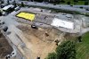
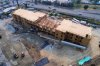
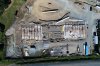
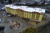
I would like to branch out and do more "technical" drone work such as roof inspections, construction progress, mapping, etc., but for now, I am doing picturesque images of industrial facilities, and other large complexes. These would be photos they would use on their websites or for wall hangings. I have done this kind of work for many years from airplanes and helicopters. My rates from manned aircraft usually ranged from $700 to $1,000 and included images taken from various angles and the client got them all and all rights.

I'm only doing still photos for now. I'm not comfortable with video yet and am concerned about getting the jello effect at times. (I use a P4P+).

I've been all over the place in my pricing using a drone, ranging from $100 to $900, but I'm striving to work within the following guidelines: For a smaller facility the price is around $350 for photography from all angles. A larger facility would be priced at $450 to $550 for photography from all angles. If they want the property also broken down with close ups of individual areas or buildings, the price would be $700 and up, depending upon how many separate areas there are to photograph. If their budget is small, I will do photography from just one side for about $250. In all cases photographs are taken from various angles and the client has many images from which to choose. I would happily do $100 jobs, however, if I had lots and lots of them, but my experience has been that they can be just as hard to get as the higher-priced jobs and can be just as spread out, so I might as well go after the higher priced work.

I would like to emphasize that I have been a professional photographer for years and that I do not believe someone without photography experience who buys a drone would be able to provide the same quality. For me the drone is just a platform as was an airplane or helicopter.
Amen to your closing statement. I’ve been a semi-pro photographer for over 40 years and it amazes me at some of the poor quality work I see on business websites. Likely taken by an unlicensed employee (or owner) or kid with a drone who does it for nothing.

I’m not at the point of having to depend on getting drone jobs...it’s a side hustle for me currently, so I turn down the $100-200 jobs. Brokerage houses don’t want to pay squat, they expect you to drive across town, sometimes get waivers, get their prescribed shots for literally peanuts. I had one offer me a whopping $1100 to shoot 16 separate sites. I did the math on the driving and it added up to over 350. Drive time literally 6 hrs on a good day. I’ve been building my LLC brand for nearly 5 years now (jetsonaerial.com) and unfortunately for me at least, I’ve watched the opportunity for drone photography diminish day by day. When you consider the price of drones, the flooding of the market, and the fact everyone is a “photographer” these days.

I do have a few clients who understand and appreciate the value of having quality images of their projects and they stand by me even though other pilots try to under bid me for their business.

Aerial Photography...a business that’s working it’s way to the bottom. Ironic isn’t it?
 

Members online

No members online now.

Forum statistics

Threads
4,290
Messages
37,652
Members
5,987
Latest member
Harley1905