Welcome, Commercial Drone Pilots!
Join our growing community today!
Sign up

Drones with measuring capabilities

BenJammin91

New Member
Joined
Mar 9, 2022
Messages
1
Reaction score
0
Age
35
Hi, I’m reaching out to anyone who may know what, if any drone has the capability to measure objects… whether that is possible during flight or even possible after flight if I load the images or videos into some software programs. I currently have a DJI mini 2 that I have used for fun but now I’m currently starting to work commercially and need to upgrade to something that provides better video quality and more features. I’m on the fence with the matrice, Inspire 2 and the Mavic 3 cine.

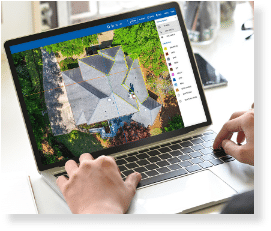
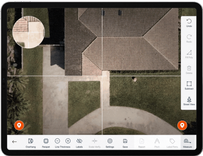
More importantly I need to be able to measure and find dimensions of objects such as HVAC units, highway road signs, the area of roofs, and 3 dimensional pics of radio towers and powerline towers.

Which if any drones have the capability to do these things?

Thanks for any and all input!

-BenJammin
 
It's not the drone, it's the software. I use Drone Deploy, it isn't cheap but it is great software. I have done many volume and pile reports with DD using an Inspire 2. If you really want accuracy go with an RTK drone.
 
As @R.Perry indicated, for volume measuring of construction & material piles, Drone Deploy subscription or several Photogrammetry / 3D modeling programs have the capability to provide. A common owned program is MetaShspe. Drone Deploy is a very capable product that simplifies the Process with nice results & products. It is a pricey tool & subscription… if busy, then may be justified.

You’d have to explore yourself, not sure Drone Deploy can meet all your requests. Capturing mapping images with MapsMadeEasy and creating a photogrammetry image can create nice results.

You may find MadeMadeEasy meeting your requests. Probably the quickest & easiest tool for quick work and relatively accurate measurements. MapMadeEay & it’s low cost sevice to generate image provides nice 2D images and includes onscreen tools to measure parts of image: wall length, H/AC dimension, etc with good accuracy. These won’t be associated to specific GPS ground points without additional steps… but just for measuring & area, it’s a quick use and accurate tool.

There are several roofing apps that do a great job estimating roofs and drawing them accurately with dimensions. Some are very impressive & quick.

Although, with many (including roofing apps) you’ll need to provide a little input data to obtain scale & slope. For 3D modeling, or obtaining size or dimensions… again you’ll need to provide a reference scale within at least 1 image.

Also keep in mind if you’re wanting to create 3D Modeling, that’s not a simple task. It requires quality & ample accurately captured images. A great modeling product is Reality Capture, as well as MetaShape. Reality Capture has a very low cost method.

There is no “point & shoot” program or drone that will quickly generate all your requests easily… and aerial imaging will have a margin of error in accuracy of measurement. You mention signs, if you’re wanting tape measure accuracy… you’ll have a margin of error.

Learning programs & obtaining useable images has an experience curve. Similar to learning Photoshop in comparison to a simple phone app; it takes time & practice to obtain desired results.

Good Luck, Welcome to the Forum, and enjoy the experience.
 
Last edited:
I meant to include comments on crafts.
The ones you mention: M210, Inspire 2, M300, & Mavic 3 Cine.
Not knowing your preference for size of platform & portability... the M210 & M300 are larger platforms.
The M210 & Inspire 2 are older platforms on older Radio transmissions and the M300 a relatively new platform and total package is pricey if not justified.

The Mavic 3 is the newest, but doesn't support the tasks you desire... it currently lacks the SDK to 3rd Party developers for creating & performing waypoint mapping missions. The Mavic 3 when SDK is released, will not have the ability to process the missions on-board, it'll be processed on tablet and transmitted... like all FLY App crafts (Mini2, Air2, Air2S, etc)... this doesn't effect mission overall unless connectivity is lost between RC & Craft.. it would not be able to continue the mission and return home. On the positive, the improved OcuSync of the M3, may help it avoid RC disconnects. The Crafts using Go4App (or Go3App) can continue missions if RC connection is lost: M210, Inspire 2, Mavic 2P, etc.

As stated by @Ajkm the Mavic 3 shutter is not a mechanical shutter. Although several tests have verified it's fast capture and leaf shutter produce essentially identical results to mechanical below 1/2000. (Edit * my error, M3 does not contain a leaf shutter like X4S, but is fast capture) With the design of a leaf shutter it won't experience the rolling shutter image distortion. It also produces very good images when several have manually flown a mapping mission, although until SDK is released mapping would not be one of the Mavic 3 operations.

The Inspire 2 using the X4S is identical to the Phantom 4 Pro... same camera with mechanical shutter below 1/2000. The M210 can also use the X4S and carry heavier payloads like the XT2 Thermal if desired.

Personally, I'm not sure I'd invest in Inspire 2 or M210 at this time period. The M210 was essentially replaced with the M300 and the Inspire 2 is an older LightBridge Transmission soon to be replaced. I'd probably suggest the Phantom 4 Pro v2 or the Phantom 4 RTK, although many have successfully used the Mavic 2 Pro despite it's camera not being mechanical. Other Brands: Autel EVO 2 Enterprise is an option too.

I own & use multiple Inspire 2, several X4S, X5S & X7 payloads, M210 & XT2 640, M600Pro's, P4Pv2 and majority Mavic's including the M3Cine. I like the Inspire 2 and will continue using it but it's no where near as stable platform as the Mavic series.

I'd grab a used Phantom 4 Pro v2, and wait to see the new Inspire 3. The cost of the P4Pv2 isn't prohibitive and can be sold if no longer needed. If the Inspire 3 is released under the FLY App, then you can reassess for other options.
 
Last edited:
As @R.Perry indicated, for volume measuring of construction & material piles, Drone Deploy subscription or several Photogrammetry / 3D modeling programs have the capability to provide. A common owned program is MetaShspe. Drone Deploy is a very capable product that simplifies the Process with nice results & products. It is a pricey tool & subscription… if busy, then may be justified.

You’d have to explore yourself, not sure Drone Deploy can meet all your requests. Capturing mapping images with MapsMadeEasy and creating a photogrammetry image can create nice results.

You may find MadeMadeEasy meeting your requests. Probably the quickest & easiest tool for quick work and relatively accurate measurements. MapMadeEay & it’s low cost sevice to generate image provides nice 2D images and includes onscreen tools to measure parts of image: wall length, H/AC dimension, etc with good accuracy. These won’t be associated to specific GPS ground points without additional steps… but just for measuring & area, it’s a quick use and accurate tool.

There are several roofing apps that do a great job estimating roofs and drawing them accurately with dimensions. Some are very impressive & quick.

Although, with many (including roofing apps) you’ll need to provide a little input data to obtain scale & slope. For 3D modeling, or obtaining size or dimensions… again you’ll need to provide a reference scale within at least 1 image.

Also keep in mind if you’re wanting to create 3D Modeling, that’s not a simple task. It requires quality & ample accurately captured images. A great modeling product is Reality Capture, as well as MetaShape. Reality Capture has a very low cost method.

There is no “point & shoot” program or drone that will quickly generate all your requests easily… and aerial imaging will have a margin of error in accuracy of measurement. You mention signs, if you’re wanting tape measure accuracy… you’ll have a margin of error.

Learning programs & obtaining useable images has an experience curve. Similar to learning Photoshop in comparison to a simple phone app; it takes time & practice to obtain desired results.

Good Luck, Welcome to the Forum, and enjoy the experience.
I'm curious about the several roofing apps which you mention. I currently use Drone-Deploy's Roof Report, but what others are available?
 
As @R.Perry indicated, for volume measuring of construction & material piles, Drone Deploy subscription or several Photogrammetry / 3D modeling programs have the capability to provide. A common owned program is MetaShspe. Drone Deploy is a very capable product that simplifies the Process with nice results & products. It is a pricey tool & subscription… if busy, then may be justified.

You’d have to explore yourself, not sure Drone Deploy can meet all your requests. Capturing mapping images with MapsMadeEasy and creating a photogrammetry image can create nice results.

You may find MadeMadeEasy meeting your requests. Probably the quickest & easiest tool for quick work and relatively accurate measurements. MapMadeEay & it’s low cost sevice to generate image provides nice 2D images and includes onscreen tools to measure parts of image: wall length, H/AC dimension, etc with good accuracy. These won’t be associated to specific GPS ground points without additional steps… but just for measuring & area, it’s a quick use and accurate tool.

There are several roofing apps that do a great job estimating roofs and drawing them accurately with dimensions. Some are very impressive & quick.

Although, with many (including roofing apps) you’ll need to provide a little input data to obtain scale & slope. For 3D modeling, or obtaining size or dimensions… again you’ll need to provide a reference scale within at least 1 image.

Also keep in mind if you’re wanting to create 3D Modeling, that’s not a simple task. It requires quality & ample accurately captured images. A great modeling product is Reality Capture, as well as MetaShape. Reality Capture has a very low cost method.

There is no “point & shoot” program or drone that will quickly generate all your requests easily… and aerial imaging will have a margin of error in accuracy of measurement. You mention signs, if you’re wanting tape measure accuracy… you’ll have a margin of error.

Learning programs & obtaining useable images has an experience curve. Similar to learning Photoshop in comparison to a simple phone app; it takes time & practice to obtain desired results.

Good Luck, Welcome to the Forum, and enjoy the experience.
I'm curious about the several roofing apps which you mention. I currently use Drone-Deploy's Roof Report, but what others are there?
 
I'm curious about the several roofing apps which you mention. I currently use Drone-Deploy's Roof Report, but what others are there?
The ones I've examined are Roofsnap, EZ-Roof, EZ-3D, Imging, and Drone Deploy.

Probably the most popular is RoofSnap, followed by EZ-3D.

The Imaging Company is probably the most complete, but also pricey. I didn't care for them a few years back because they required you used their Phantom Kit and took their classes. I think since then, they've backed off some and provide... but still looks more control to me.

RoofSnap:

EZ-3D:

EZ-Roof:
This now appears to be part of EZ-3D product.

iRoofing:


New Entry:
EZFly Roof Inspection:
 
  • Like
Reactions: MikeA
The ones I've examined are Roofsnap, EZ-Roof, EZ-3D, Imging, and Drone Deploy.

Probably the most popular is RoofSnap, followed by EZ-3D.

The Imaging Company is probably the most complete, but also pricey. I didn't care for them a few years back because they required you used their Phantom Kit and took their classes. I think since then, they've backed off some and provide... but still looks more control to me.

RoofSnap:

EZ-3D:

EZ-Roof:
This now appears to be part of EZ-3D product.

iRoofing:


New Entry:
EZFly Roof Inspection:
Thanks. I'll check them out.
 

Members online

No members online now.

Forum statistics

Threads
4,277
Messages
37,605
Members
5,969
Latest member
KC5JIM