

- Joined
- Jul 5, 2019
- Messages
- 68
- Reaction score
- 24
- Age
- 48
Hello all!
I have a Golf Course that is very interested in my services, but they are located within a Class C airspace, near LBB International. I have submitted 4 LANNC authorizations for a 200' ceiling for mapping and turf analysis, but have gotten them denied due to the FAA not reviewing them. I have submitted 2 with a 2 week lead time and am on my second pending for 30+ days submission prior to the flight.
The first three were submitted through Airmap and my current and still pending is through Skyward.IO. The app also states to not call ATC, as it may cause delays.
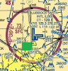
What can I do to see where I am in the process? Myself and the customer are frustrated. The green area in the attached picture is the approximate location of the Golf Course.
Any input is appreciated!
I have a Golf Course that is very interested in my services, but they are located within a Class C airspace, near LBB International. I have submitted 4 LANNC authorizations for a 200' ceiling for mapping and turf analysis, but have gotten them denied due to the FAA not reviewing them. I have submitted 2 with a 2 week lead time and am on my second pending for 30+ days submission prior to the flight.
The first three were submitted through Airmap and my current and still pending is through Skyward.IO. The app also states to not call ATC, as it may cause delays.
What can I do to see where I am in the process? Myself and the customer are frustrated. The green area in the attached picture is the approximate location of the Golf Course.
Any input is appreciated!

") Been down the zero grid road too many times, passed on plenty of jobs.
Been down the zero grid road too many times, passed on plenty of jobs.


