LUIS MARTINEZ
Well-Known Member
- Joined
- Dec 24, 2017
- Messages
- 1,218
- Reaction score
- 1,048
- Age
- 73
- Location
- CASA GRANDE, AZ
- Website
- www.martinezaerial.com


Hi,If you have any question in thermography, I will try to address it.
Hi,
I'm wondering about determining emissivity on a roof inspection? My client doesn't require an exact temperature reading but would like something nearly accurate. (Quantitative lite I guess - lol) The subject roof is highly reflective.
The majority of my targets are roofs and PV arrays, so those parameters don't really come into play for me. Qualitative data only, so far. Also Search and Rescue. I am interested in how you are using thermal technology in oil and gas. Care to share?Hello All, studying for part 107 but have 13 years experience as a level 1 thermographer in the oil and gas sector. For everyday scanning I typically use a 0.95 emissivity. Wondering what you guys are using for UAS surveys? Do you change it depending on the item of interest or just roll with one emissivity? In my experience distance plays a pretty big role in accuracy. How close are you flying above your subject while scanning?
I use FLIR tools any other software you guys prefer?
Thanks for your input!
DJI Matrice 210, FLIR XT2, Zenmuse Z30.
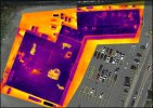
I don't see why not. Personally I have never done it but have been a thermographer for over a decade. Of course some factors will come into play such as time of day you perform the scan. Ideally you want the temperature delta to be at its greatest when you scan so it is easier to identify the cooler areas. I would think a morning scan might be your best bet but again my background is not in scanning roofs so maybe someone can chime in on best time of day. When I was scanning tanks for sediment, an early morning scan would give the greatest temperature delta between the liquid in the top of the tank and the sediment in the bottom. If these are the blue glass coated tiles you will have more difficulty due to the reflection of the IR off the glass. The standard Spanish tiles will probably work well.Good Evening , I am pretty new on the Forum Forgive me if this has been asked previously . I wanted to know if it’s possible to do a Thermal scan on a Clay tile Roof trying to find moisture .
No equipment yet -Have my eyes on the Mavic 3T . Thanks for having me .
Thank you very much for your prompt response . Appreciate all the tips that you have provided . This would be my first work Using Thermal Camera , so want to be very careful if the job can be done .I don't see why not. Personally I have never done it but have been a thermographer for over a decade. Of course some factors will come into play such as time of day you perform the scan. Ideally you want the temperature delta to be at its greatest when you scan so it is easier to identify the cooler areas. I would think a morning scan might be your best bet but again my background is not in scanning roofs so maybe someone can chime in on best time of day. When I was scanning tanks for sediment, an early morning scan would give the greatest temperature delta between the liquid in the top of the tank and the sediment in the bottom. If these are the blue glass coated tiles you will have more difficulty due to the reflection of the IR off the glass. The standard Spanish tiles will probably work well.
Thanks for the info John. For the asset owners and prop management gigs, does that work include thermal or more just providing aerial visuals for them? If thermal, what's the average percentage?@Outta Control I focused my time on asset owners and property management companies and currently have all the work I can handle.
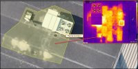
So I guess the percentage would be 100 thermal usageI only do Thermal work. The asset owners are small business that own their own building. The property management companies are managing many large assets with multiple chain and anchor stores. Like a Home Depot plaza. They manage all facets of the property including building upkeep. We provide a proactive approach to roof life cycle management. Baseline scans for proactive moisture remediation and reoccurring scans every 24 to 36 months to minimize business continuity and ultimately extend the life of the roof.
 . Maybe I found an open window down the hall. Thanks John. Much appreciated.
Always glad to share my $.02.So I guess the percentage would be 100 thermal usage


We use essential cookies to make this site work, and optional cookies to enhance your experience.
")